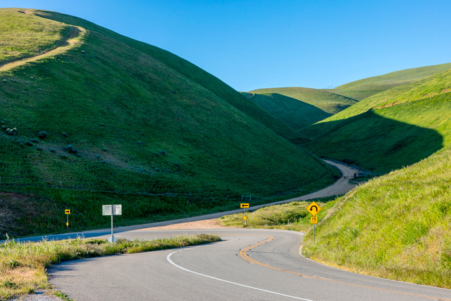
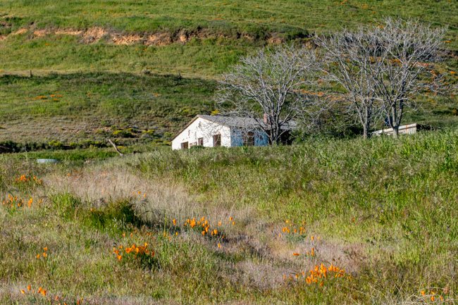
We arrived in Salt Lake City the afternoon before so that we could get an early start for our visit to the Kennecott-Bingham Copper Mine, located southwest of the city in the Oquirrh Mountain Range. The mine is the largest man-made excavation, and deepest open-pit mine in the world. It’s the yellow patch in the Goggle Maps view above.
I have wanted to photograph here for several years, to include in myInto the Anthropoceneproject. Everything we consume, comes from the ground somewhere, somehow. The Kennecott-Bingham Mine is a primary example of what that looks like. Seeing how our need for natural resources affect the land and environment, can help us understand the true cost to our environment.
It is not always easy arranging things. A planned visit two years ago, as we passed through, went awry when the region’s air was thoroughly fouled by western forest fires for weeks, and temperatures nearly reaching 100. I really needed clear skies for this work.
We’d left the warm weather behind around Zion, and the wind-chilled air here in Salt Lake, I considered as more of a gift to image making. It will be cold up there, but oh so clear. I panicked a little the night before as I attempted to purchase visitor tickets online to get access to the viewing platform. I missed the cutoff time and worried it would be sold out. It is a National Historic Landmark after all.
We hustled out early and were driving by tailing piles as high as mountains about 30 minutes later. The mine wasn’t hard to find – it tends to stand out. Copper was discovered here in 1848 by the Bingham brothers who reported their discovery to their leader Brigham Young who advised against pursuing mining operations because the survival and establishment of settlements were of paramount importance at that time.
It wasn’t until 1863 that ore extraction began and the potential of the canyon’s mineral resources began to be widely recognized. The canyon’s 19th Century mines were relatively small, and it wasn’t until the end of the century that very large-scale exploitation of the canyon’s ore bodies began to develop using the techniques of open pit mining. The land where the original town of Bingham Canyon, population 15.000, was situated, is now part of the Kennecott Open Pit Mine.
I wanted to be on the first transport up there, so we were at the ticket office at 9:30. I needn’t have worried about crowds. On arrival, there were just six others waiting to go. Later in the summer it will be a different story. We were up on the mountain by 9:45.
It was something of a profound experience looking down into the pit – the bottom of which too deep to see. It is stunning what humans can do. The viewing area is on two levels, and is situated maybe a third of the way down into the pit. Each level provides a slightly different perspective and I was free to move around these areas.
At first blush, the place seems to be just a big empty hole. Looking closer though, movement is detected and slowly I began to see the trucks. The constant activity of dump trucks kept my eyes moving around the scene. I watched as dozens of massively huge dump trucks hauled loads of ore to processing areas. They seem tiny from here, but when I saw a yellow school bus parked nearby, I got a better sense of their true size.
The viewing area allows one to walk around to see various sections of excavations going on. One area for loading, another, road repairs or construction seems be progressing. Some portions of the hillsides seemed to be melting into the pit.
We spent a couple of hours walking around the viewing area, but eventually it was enough. It was kind of exciting making dramatic images, but also, seeing the environmental destruction is daunting. On the way out we stopped again to gaze at the mountains of tailings, now revegetated. I hear a housing project is being considered for nearby.
We are heading north once again. After an overnight stay in Pocatello, ID, we will finally get to Yellowstone on Friday. I’ve know it will be cold, but there is talk of a major snow storm brewing-up for next week so there is a little uncertainty.
Traveling north again, we stopped in Kanab, Utah for two nights. This is another area we have explored to some degree, but this time, we are going to do an old favorite by spending a morning driving the east side of Zion National Park to the tunnel that divides east from west sides.
The entrance to the park is about 40 miles from Kanab and an easy drive. The sandstone formations along the stretch of road are truly amazing. Making photos along here is a delightful experience.
Our first stop of the morning was at Checkerboard Mesa, a massive petrified dune towering above the canyon. Over eons, erosional forces segmented it in such a way that Checkerboard seems an appropriate name. It is difficult to express just how large these formations are. Mary standing near the base of Checkerboard, did the trick.
The rainbow colors and textures drew me in and we spent an hour walking the area. It is always a surprise and delight finding the little elements that add up to a visual story. I enjoy bringing these things together into a picture.
This early in the morning there isn’t much traffic, but as it is Sunday, I expect it will increase quickly. These first hours, though, the place seems like ours.. Traveling along the highway, we stopped at almost every turnout – both to let the increasing traffic go by and because there is so much to see that one must stop, get out, and look around.
At another stop, we walked down to a dry wash below another sandstone mountain. The seams and veins of the varied formations all came together here, with color on top of color and layer upon layer of solid rock.
The early morning light provided wonderfully long shadows and helped to highlight the flora all around us.
Traffic was increasing quickly and we soon found ourselves stuck in a long line of cars. Often this can mean wildlife on the road, but I knew from experience that in this case, it meant a hold-up at the tunnel. RV’s and trucks must make appointments to travel through the tunnel that leads to the west side of Zion. This causes delays as a caravan of trucks must travel single file down the middle of the tunnel, while regular traffic must wait going both ways. The single two-way tunnel has curved sides that sit too close to the lane and scrapes and crashes can easily happen. I wanted to go as far as the tunnel turnaround area, but after waiting about 20 minutes with little movement, we turned around and headed back to camp.
Big Rock Candy Mountain April 29
We left Kanab and headed north again, this time ending up at an RV resort known as Big Rock Candy Mountain. This not the place Harry McClintock sang about in 1928, but you can get lemonade and ice cream in the cafe. Big Rock is situated in a canyon bordered on one side by a massive yellow mountain.
Photo by Mary G
They used the location as a candy theme – coloring their associated motel in pastels and giving the rooms names such as Cotton Candy Cottage and Chocolate Chalet. It is always a little sad to see these places off-season. We were nearly the only folks staying here this day, but I could imagine the place is hopping all summer long.
We took the briefest of walks around the grounds to get a sense of the place. We walked over to the big yellow mountain, but declined to hike up to a spring we were told existed up there. Afterward, we indulged in a bit of ice cream and talked a while with the owner and her cute little 3-year old daughter.
Tomorrow we drive to Salt Lake City for another two day stay. We needed to catch up on laundry and restock before entering Yellowstone for five days of dry camping. The weather is turning cold and we are not sure what will await us there. In Salt Lake, I want to do more work on my ongoing Into the Anthropocene project, and the Kennecott/Bingham copper pit mine near the outskirts of Salt Lake is the largest mine of it’s kind in the world.
April 25 – 26 We got out of Dead Horse State Park at our usual mid-morning time on Thursday, and headed north to Page Arizona. I was able to get reservations online to walk through Lower Antelope Canyon on Friday and it wasn’t a long distance to drive. I was expecting an uneventful drive up. The predicted rain was going to hold off until later in the afternoon, so smooth sailing.
That was mostly correct. However, I didn’t account for the wind that usually precedes a storm. I took over the driving after about 50 miles, as the winds really began to pick up. These pictures are Mary’s. To our east, dust was flying 80 ft. in the air, while also beginning to rise up and across the road we traveled.
It was looking pretty bad, but strangely, it was not difficult to drive. The Lazy Daze was very stable on the road – I wasn’t getting pushed around. By the time we arrived in Page, the wind had died down considerably and all that was left to do was find our camp.
The Antelope Point RV Park seemed brand new. It is tribal run and sits just inside the Glen Canyon National Recreational Area boundaries. There is a marina here, as the park sits above the Colorado/Glen Canyon reservoir, on a bluff. Much better than being in town.
Lower Antelope Canyon Friday, May 26 It had been many years since we had done this walk. It wasn’t as well known as the Upper Antelope Canyon – but was becoming more popular even then. On that visit, we showed up at the ramshackle booth with backpacks and tripods, and because I bought the special Pro Photographers package, were directed to a guide standing at the entrance to the canyon where we were told to take our time, but move along steadily. We probably spent two hours walking the 3/4 mile path. They were actually pretty serious about the pro photographers stuff. They refused to let one man go because they said his camera wasn’t a professional camera.
Today, we showed up about 45 minutes early for our slotted time. There is a big new visitor center now and another gift shop nearby. We signed the release from liability form, listened to the “do’s and dont’s” – mostly “dont’s” and went to wait in the outdoor seating area.
While waiting, a Navajo man stepped out with a set of color striped rings and a boom box, to perform the Hoop Dance. It was an enjoyable performance, but at times, he had just a bit of trouble slipping through the tight rings. He was required to move up to the senior group next year. I hope they have bigger rings.
By the time he finished, the rather large line that had queued-up to walk the canyon for earlier time slots, had been separated into groups of 15 and guided to the canyon.
It was a bit disappointing to see how many people were queued up for the tours, but the way the tribe has arranged it, the groups move steadily along. While it is hectic, it serves to get people through this hugely popular attraction most efficiently. Gone is the time when one could stand in a spot to consider a composition for a few minutes. For most folks, the experience of walking the canyon – and getting the selfie – is the attraction.
When our time arrived, we were guided to the lower entrance to start our walk. We could only carry our cameras and water with us. No tripods, monopods, selfie sticks, bags or backpacks of any kind, Then down into the canyon we went.
The previous group waiting to descend into the slot.
Once in, shapes and light take over. Initially, it is a bit overwhelming because everywhere looks good. Where to begin? There isn’t a great deal of time to think about it. I started by pointing the camera where people weren’t. That was up.
While it was often difficult to get a good composition without people’s heads in the way, it was possible. A little patience, everyone moves along eventually. I found that if someone blocked an image I wanted, I would stand aside and just study the spot until I could get into place. Once there, I mostly knew the framing I wanted and could make the image quickly, then move on.
Actually, letting people appear sometimes adds a bit of perspective to the scene and might be the only way to get a particular image.
There was a guide with us throughout the walk. She did her best to keep us together, without also letting us get too close to groups in front and back of us. It took lots of maneuvering and cooperation with others, but I felt like I came out with some really nice images. I did get separated from my group somehow. I was lost in image making. I thought I had fallen into the group behind me, but actually was ahead of my group. I just followed the guy in front of me. Oops!
From Wikipedia: Antelope Canyon was formed by the erosion of Navajo Sandstone[2] due to flash flooding and other sub-aerial processes. Rainwater, especially during monsoon season, runs into the extensive basin above the slot canyon sections, picking up speed and sand as it rushes into the narrow passageways.[7] Over time the passageways eroded away, deepening the corridors and smoothing hard edges to form characteristic “flowing” shapes.
I don’t really have more to add about these images, so just enjoy the rest!
I did recognize a few areas from the last visit. Some were so exceptional – in fact, were the reason I wanted to return and photograph here again.
At the end of the 3/4 mile trek, we emerged through another stairway out of a crack one would never have guessed was the exit from a magical place. All in all, it was a good experience. The Navajo guides are friendly and helpful and will talk at length about Indian history.
We were done before noon, so we traveled a few miles south of Page to the Horseshoe Bend Overlook. It’s a rather severe bend in the Colorado River that is pretty spectacular. Last time here, we just drove to a primitive parking lot and walked the quarter mile to the edge. That’s not possible now without a day use ticket from the Navajo. I would have paid the $10 bucks to go look, but the wind had come up and dusty sand was blowing everywhere – and it was mobbed. We turned around and went back to camp.
Later in the afternoon, we took a little walk around the campground area. Over near the boat ramp, we walked the canyon rim overlooking an arm of the Lake Powell Reservoir.
It was a short but sweet stay here in Page, but tomorrow we continue our trek to Yellowstone. We will be stopping in Kanab, UT for just two days to help break-up the driving days. Also, there is a certain strip mine in Salt Lake City – the largest copper mine in the world in fact – I would like to visit after Kanab, so a two day stop will also be in order.
It was an easy 60 mile drive to Dead Horse Ranch State Park. We arrived a little early, so we took care of some business before checking in. The days were still getting pretty hot because of a high pressure system parked over Arizona the past 4 days. For at least the next two days however, we will be hanging out here, walking the three large ponds early and late. I’ve seen wildlife here ranging from river otters to havelinas and roadrunners.
But even when the fauna are scarce, the flora rarely disappoints. I especially enjoy the reflections in the sill waters of the ponds this early. We were out there just a little after dawn. Only, a few walkers and a couple folks fishing.
I was hoping for some wildlife sighting this morning. I’d heard a Bald Eagle was hanging around the area. A Great Blue Heron flew by as we walked in, but not a lot else seemed to be around. There were quite a few Grackles chirping in the trees and shore grasses. One in particular posed for a few images on a branch near me.
This bird, though all black, has long lovely tail feathers that spread out each time it calls. As it moves around, the iridescence of it’s feathers really shown.
But it was soon back to reflections and a few flowers along the shore.
In an especially thickly clogged area of reeds, I noticed a few Red Winged Blackbirds flitting around and calling. Up close, they are quite nice.
The lakes are fed by the Verde River, and several varieties of fish frequent the waters. This catfish didn’t seem too concerned. We spent a several hours walking around the ponds, but were ready for a little breakfast back at the rig. During the heat of the day, we caught up on blogs and shopping and keeping cool.
Wednesday, April 24 This evening we wanted to do a second walk around the lakes. It was another very hot day, but the evening had cooled, so out we went. I was still hoping to see some more wildlife, but there wasn’t much happening. Oh, but the reflections were still there and the light was different.
A cute little mallard and the Heron below did make a late appearance as we were leaving. Tomorrow we head north to Page Arizona for two days. It is so tempting to want to stay longer at most of the places we have visited, but we have to be in Yellowstone by May 3, so we are trying to balance all the driving with a little photography.
We showed up on Janet and David’s doorstep in the afternoon on Friday. Our arrival was announced about a quarter mile before by their four dogs who just couldn’t wait to meet us. This is our first visit with J & D since before the pandemic and it was surely good to see them both happy and reasonably healthy. They had recently moved down from the tiny town of La Sal in Utah for a more reasonable altitude and to be closer to decent health care.
While Mary and Janet visited the dogs, David and I retreated to his office, where we looked a some of his photographs. He is a completely self-taught photographer and wanted advice on how he was doing. I was able to offer some tips, but he was doing quite well on his own. We later sat down to Janet’s wonderful lasagna dinner while we caught up on the past 5 years.
Saturday morning we were out the door and headed to Watson Lake. Mary told me we had been here some years before, but I had little memory of place. Mountains of large boulder piles, reminiscent of the Alabama Hills or Joshua Tree National Park, surround a reservoir whose waters are too polluted with toxic mining materials for swimming. The city of Prescott felt it was still useful as a recreational site, so created a hiking and climbing resource for the area. It is actually quite beautiful. There is camping, and hiking trails are many.
The day started out very warm and was getting hot by the time we arrived at the lake. Janet picked out a nice 2 mile loop hike that would take us high along a ridge of the lake, down to the dam and back. Our hiking app had it at 2-miles as well. In reality, it was 3-plus miles, quite rocky with lots of ups and downs. My only complaint about AllTrails is that the distances are often not quite accurate.
There were interesting rock formations early on, that resembled cinnamon rolls – or maybe I was just hungry. Lots of cactus and plenty of views.
One little formation resembled a elephant head if one stood in just the right spot.
We eventually arrived at the dam and found a nice cool shady lunch spot near the base. Here we could watch a few birds and other small critters frolic while we ate and rested up. It was now quite hot and we were all feeling it.
Finishing lunch, we headed out again, this time following along the canyon. From a distance, I could hear people calling out to one another. As we got closer, I finally located the source. A climber was ascending a shear rock face. She seemed stuck at a certain point and kept calling out, “I’m not strong enough!”. She kept trying though, and seemed to have completed the move as we moved past.
The trail moved us up higher along the ridge and revealed some nice rocky landscapes. There was also just a bit of a breeze up here. Something we all needed as the temps hit the mid-80’s.
In the end, we were all gassed and nearly out of water. On this day, the trail was more than moderate as it was described in AllTrails. It was a good hike – just too hot for us. We returned home, rested up a bit and had a nice dinner out.
Perkinsville Sunday, April, 21
A good night’s sleep did us all some good, but we were not up for another hike in this hot weather. We opted for a drive and photograph kind of day and Janet was kind enough to do the driving again. This time, we drove towards the ghost town of Perkinsville. While we weren’t going to get to the town itself, we did travel through some interesting terrain.
From an overlook, we got a panoramic view of that included the San Francisco Mountains with some amazing sandstone hills in the foreground. The haze in the sky was a little disappointing, but you get what you get on any given day.
We explored the road, stopping from time to time, until about midday when we came to the Perkinsville Bridge over the Verde River. Just nearby, train tracks and a crossing.
At the south end of the bridge, a corral with a traditional natural tree limb fence sat. A very rural scene. We played here for a while, but lunch called.
Janet suggested getting out of the heat so we parked ourselves under the bridge, along the river bank. Several other groups were nearby. It was really the only shady cool area around and it was a very welcome respite.
After lunch we were all ready to head back. We stopped again at the earlier overlook and found the clouds had increased, and the haze decreased.
We only made two other stops. Both for large Bull (or gopher) snakes. The first was quite large, but was half in the road and half in a bush – we couldn’t see its head. The second was just a mile or so later. It was sunning itself fully in the road. Their bites would hurt, but no fangs, no poison. They are amazing to watch.
We finished our stay with a dinner of cowboy spaghetti – cooked by Mary and enjoyed by all. We said our goodbye’s in the morning and headed out about 50 miles to or next destination for a couple of days. We managed to get a reservation on short notice at Dead Horse Ranch State Park in the town of Cottonwood.
Tuesday, April 16 Another early start this morning. We packed the Rav again and headed out to the Alabama Hills that sit behind the town of Lone Pine. But first a visit the local information center where we spoke with a very helpful volunteer about where to find the sparse wildflowers throughout the hills. It helped a lot knowing the hills pretty well when she pulled out a map and started circling various areas to explore. Even so, we needed our GPS and AllTrails and a paper map to actually find the spots.
The Whitney Portal Road into the hills was still closed off for repairs at a vital point, so a rather convoluted detour route was still required to get to Movie Road that is the access route for everything we want to picture.. Not a big deal really – I drove our motorhome through this narrow route to get to our campground last fall.
There were several areas we were interested in. The first was the loop trail to Mobius Arch. I first saw this arch in a Galen Rowell image in the 80’s before it became so well known. With a little research, found it myself. We have visited often since then. Now it is well marked.
The real draw for us were the wildflowers today. They were not in abundance, but sometimes that can work in one’s favor. Along this trail there were some nice little arrangements that I worked to highlight.
The Mobius Arch is quite impressive and it’s pretty easy to climb around. I like to get here early for the nice light and to avoid the many other hikers who will be all over this thing later. The wildflowers will have to wait.
A smaller arch sits just around another set of rocks nearby. Just in the same area, I found some nice groups of Paintbrush.
The Sierra’s are ever-present when traveling through the hills, so they end up in lots of images. They cannot be ignored, so the camera swings to them often.
Having stopped at the visitor center turned out to be vital. The small caches of flowers we found were sometimes nestled into small alcoves off the main road. In one area, nice groups of Chia compelled me to get belly-down on the ground.
In another area, more Paintbrush and Orange Mallow sprouted.
Desert Trumpet is a challenge to photograph, but I like this low viewpoint. By around mid-day we had visited all the areas we wanted to. The light had gotten pretty harsh anyway, so we found a nice viewpoint for lunch and just enjoyed the view. Tomorrow we head out to Arizona.
On the Road – Barstow Wednesday April, 17
This morning, before hitting the road, we decided to indulge ourselves with the local breakfast cuisine at the Olancha Cafe situated adjacent to our campground. It was lovely cool morning start to our day and there was no real reason we had to get out quickly. Mary was very happy with her food design.
We will be visiting for a few days with friends in the Chino Valley of Arizona, but it will take us a couple of days to get there. Especially once we get into Arizona, the highway roads can get pretty bad. Driving 300 miles over the rough portions gets really old, so we split that distance and get some down time in between.
Our stop for the night in Barstow was at Shady Lane. We’ve come here for overnighters several times over the years. It’s was kind of funky back 20 years ago and hasn’t visibly changed much since then, but much has been upgraded. It has a kind of old-timey feel, is very laid back, with quite a few full-timers living here. There is a separate area for us overnighter. It is a quiet place away from the highway.
In the morning, we took a brief walk down the road in front of Sandy Lane. Several of the homes along the road filled their front yards with sculptures made from found materials. And believe me, there are plenty of of found materials to be had around here.
We detoured down a dry wash to extend our walk a little, but soon turned around and got back on the road. After a bumpy dash across I40, we arrived in Kingman, AZ. I really stretched the gas today. We pulled in with just 4 gallons of 50. Gas is $1.50 less outside of California. Tomorrow we move on to the Chino Valley and our friends Janet and David.
The predicted near 100 degree temperatures for this week in Death Valley made the choice easy for us. We canceled our visit to the park and the extensive bloom going on there. Instead, we drove to the town of Olancha along the eastern Sierra near Lone Pine. We chose the Olancha RV Park in Olancha because of its proximity to Highway 190 and the eastern side of the nearly dry Owens Lake – and they had a cafe and TeePee’s!
Normally, 190 is the way we would have gone to DV, but it is also a quicker way to get around the lake without going all the way to Lone Pine and Highway 136. It wasn’t until we checked into our campground that we found out 190 was closed for repairs. So driving through Lone Pine was the only option.
We were out early and made a quick 30 mile drive to pick-up where we left off on our last visit here. The sky was brilliant blue after the previous evening’s light rain. The sierra peaks also received another dusting of snow.
Just a few dramatic clouds hovered across the Sierra peaks. The wind was stiff and cold. The views – just spectacular. We again found the Owens Lake Trails Plaza where we could see that the lake level had risen since our last visit in October of 2023.
That visit, I noticed a sprinkler system set-up but not operational. Today they were in full force wetting down the surrounding exposed lakebed. It made for a mucky mess of mud that limited me from getting close to the shoreline. Still, some of the walking paths were firm enough to navigate.
The berms were created out here to suppress erosion from wave action during high winds, but they also serve as environmental art and create some nice opportunities for photographs.
I wanted to get further out towards the lake this time, so we started exploring the many drivable levy’s that crisscross the dry lakebed. It is a fascinating experience driving out in this terrain. There is almost no one out here, but it is an actively monitored and adjusted as needed with water being pumped into and moved around the various ponds. I got the impression the water was fairly deep, but that was corrected when I began noticing the many birds feeding in the waters were only bird-ankle deep – just enough to keep dust from rising.
American Avocet’s were in abundance while we were there.
We continued driving the paths and stopping often. Reflections of the mountains in the lake created many opportunities. Some of the ponds were red with algae. In other areas, the water appeared green. Still others reflected the blue of the sky. These levy’s go on for miles and it wouldn’t be hard to get lost – we made a couple of wrong turns – but after a few hours of wandering around, we managed to get ourselves back out a different way then we came in.
I noticed on the drive in, the alluvials that spread out from the mountains base along the eastern shore were covered in Desert Gold wildflowers. Yes, more yellow, but we found Cerro Gordo Street – a dirt road that led to an abandoned town (which was closed). It got us right up into the flowers. We had our lunch there and also used the elevated position to get a different perspective of the lake and the nearly ghost town of Keeler.
We wrapped up our photo day and headed back to camp. We have another day in the area, and the thought is to visit the Alabama Hills behind the town of Lone Pine. I’ll be looking for more wildflowers there.
We were up and out at dawn again this morning to drive the 40 mile Elkhorn primitive road today. It’s a thirty mile drive to the start and begins by navigating the Elkhorn Grade portion. It is a steep, narrow and rutted dirt road, but is not that difficult to drive in our Rav4. I have just enough clearance to feel comfortable traversing some of the deep ruts and the all-wheel drive means less slipping in the dirt. This early in the morning there were no vehicles coming down, and just us going up.
It was a not difficult road to drive and once on top, wide views of the mountains and plains were revealed. Still not a lot of flowers along here, but I could see them starting to appear on the hills around us.
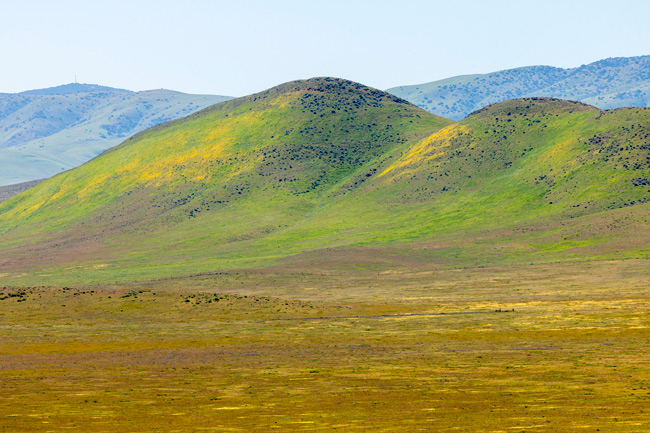
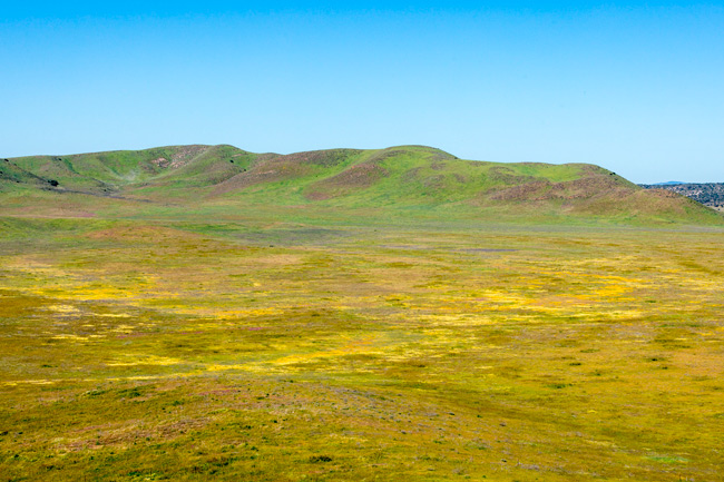
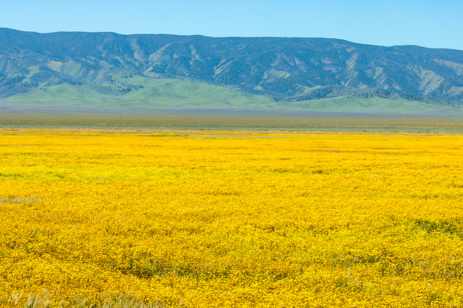
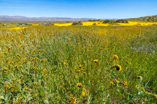
The road soon spills out to the open plain and travels along the base of the Temblor Range. These mountains were formed by the pressures of the San Andreas fault that runs through the entire length of the monument. It is largely flat easy driving.
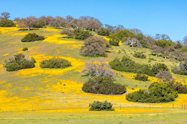
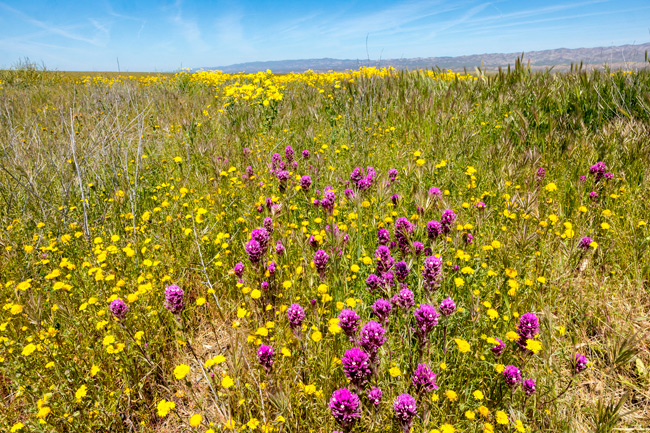
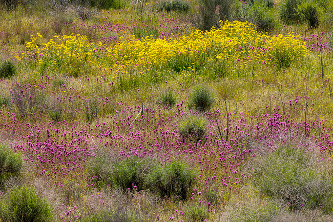
This was spectacular with flowers in 2019, but here again they were spotty. Some of the flower areas were large – they just don’t seem that way in the context of this huge monument. All the usual flower suspects were seen a various spots: phacelia, fiddleneck, goldfield, owls clover.
Looking out down the road, I couldn’t help but believe it was originally constructed as a largely straight road, but that the earth movements from the fault has caused the road to gently zig and zag it’s way through the plain.
This was the year of YELLOW on Elkhorn Road. Goldfield and Fiddleneck in abundance, and these little yellow daisy flowers I haven’t yet identified was almost all I saw.
About halfway into the drive, we came to a bypass in the road to avoid a former wet spot. As we drove it, I looked across the to the other not taken part, and saw an unexpected creature leisurely strolling down the road, chomping on the new fresh grasses. A lone pronghorn antelope was certainly not bothered by us. We just sat and watched it walk and eat before pulling out the cameras. Occasionally it would lift its head at various sounds.
Beyond there, we found more nice large areas of blooming and we continued to photograph, but by now it was beginning to seem the same. The road eventually feeds back into 7-mile road in the north end. Getting in and out of Elkhorn this way would be much easier and it’s possible to make a loop by traversing at Panorama Road. Something to consider on another trip.
The original plan was to travel to Death Valley from here, but checking the weather reports reveals temperatures will be in the high 90’s for the entire time we would be there. Sitting in an aluminum can that is our motorhome did not sound appealing. We do have air conditioning, but to use it means running the generator and that doesn’t sit well with us. So, it’s off to the eastern Sierras for several days around Owen Lake. I was really taken with the landscape on the largely dry lakebed during our las visit, so this time we hope to explore the area a little more. And maybe a few more wildflowers!
Part 1 Highway 33 – 7-Mile Road– Soda Road Wednesday, April 10
After a very hectic couple of weeks prior to leaving, we managed to get out of San Francisco and down to the Carrizo Plain to start our two month road trip. As usual, we faced a few RV issues both before and after we left. Toilet and hot water heater problems. Once on the road, those things faded away and we were left with driving and making photographs.
San Luis Reservoir SRA at the Los Banos campground
It took us a couple of days to get to Carrizo. First we camped at San Luis Reservoir SRA at the Los Banos campground which was a nightmare to find as Garmin took us to a completely different campground on the wrong side of Interstate 5. When we finally pulled in, our nice site by the lake was in reality, half IN the lake. Fortunately we could change sites and ended up in a nicer spot.
Buena Vista Aquatic Recreational Area
The next day, we moved on to Tupman, where we set ourselves up in the Buena Vista Aquatic Recreational Area for the next four days. We want to do both the east and westside roads, and this location will be good for giving us the choice of starting from either end of the monument.
This week was a nice weather window we were well positioned to take advantage of. Rain during the prior weeks had left the dirt roads impassable for a time, but they were now well dried out. With the upcoming weekend promising more rain, we managed a good couple of days in the monument between storms.
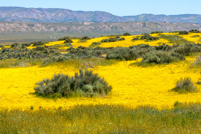
We set-out at dawn on Wednesday. There was still a 50 mile drive from Tupman to 7-mile Road north entrance. Turning onto Highway 33, the road traversed oilfields for several miles until it began to rise into the mountains leading to Carrizo. We stopped often as the road rose and twisted through the hills that separate us from the monument. Our previous visit in 2019, this road was spectacular in its flower displays. I certainly wouldn’t call it disappointing this year, though some online have. The flower displays were far from “Super Bloom” levels, but, it is a wonderful drive in on a curvy, less traveled highway.
Most prevalent were large patches of Goldfield – tiny yellow flowers that can create massive displays of color. Also in abundance were Fiddleneck, Phacillia, Daisy’s and Owls Clover. It was a bit more work composing images. Many of the hillsides were just beginning to sprout color and I was left to imagine what it might otherwise be.
The hills themselves are still interesting and worth stopping for. Steep drop-offs with wonderfully massive oak and juniper trees were all set-off by the brilliant greens of new growth. Still, there was less stopping which made our arrival in the monument a little quicker.
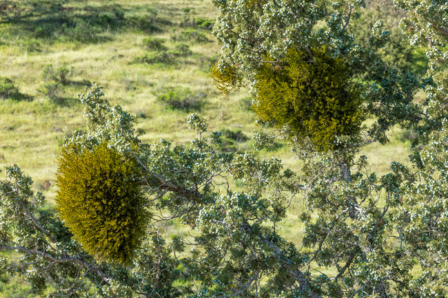
Mistletoe in a massive Juniper tree
Carrizo There was almost no blooming visible when we first turned onto 7-mile road. I’d heard this northern portion suffered a hard freeze the previous week during the rain storms, resulting in lots of dead flowers. This was apparent as there was little color and a lot of brown.
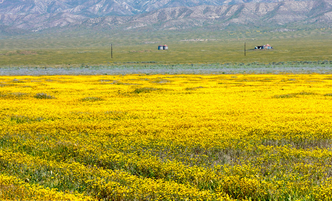
I wasn’t until we reached Soda Lake Road that we occasionally found some small to medium nice roadside displays. With just a little care with compositions, I could make it look much fuller.
Conditions changed as we drove further south. At Soda Lake, a short walking trail up a nearby hill led to panoramic views of a wide portion of the lake and plain. From up here, I could see how the hills around us were beginning to come to life again. I loved how the Temblor range of mountains reflected in the mirror smooth finish of the lake below. I made my favorite image of the day here.
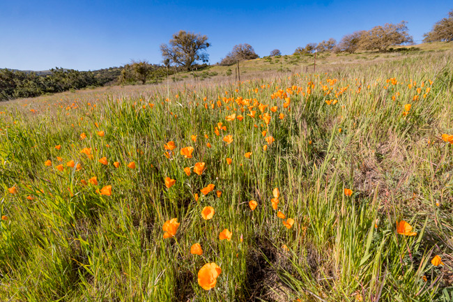
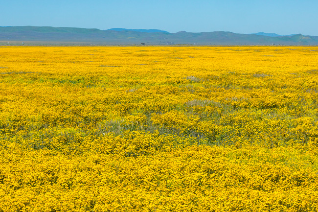
Continuing on south, there were lots of stops now for nice little mixed displays of poppies, fiddle necks and various other flowers.
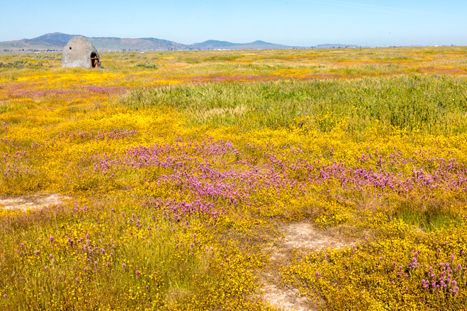
At the junction of Panorama Road, we could see a massively wide bloom of Goldfield across nearly the entire width of the plain. Despite the sign reading “Road Impassable” we had to go out there. As we got closer, I could see areas where cars may have been stuck – deep rutted and formerly muddy patches across the road. Now it was all dry and easily driven.
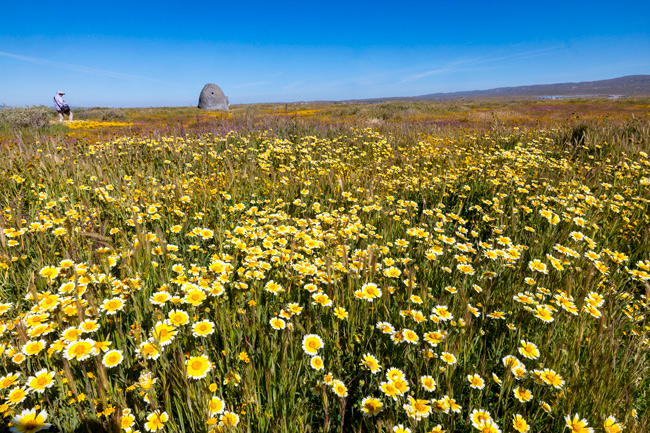
It is quite an experience standing in a field like this. Getting unique images was not easy and I don’t think I did. It’s just a mass of wildflowers, but who cares really. It’s fun just to be here.
The road looked to be in good enough shape to continue all the way across the plain to the more primitive Elkhorn Road, which travels north/south on the eastern side of Carrizo. I could see the old water troughs we drove by on an earlier trip down that road. We debated going across, but decided to stay with Soda Lake Road.
We returned to the main road and continued south. Flowers were definitely better in the southern portion, but still they tended to be spotty and there wasn’t a lot blooming on the surrounding hills either. It was looking like that might change in coming weeks. The new rain should help. I would have liked to explore some of the side roads more, but the day was getting long and fatigue setting in and we still had a bunch of driving to do. Not having any clouds was a bit disappointing. It really limits lighting possibilities to harsh overhead light.
Orange Mounds and Hoodoos Monday, April 24 During the early morning hours of Sunday night, the distinctive plink, plink, plink, of drops on the RV roof added to fears of rain on our final day in Bisti. I knew it was chancy, be we decided to add this extra day because there was just so much more to explore out here. If it didn’t rain, it could be a great day. Most other visitors had cleared out Sunday afternoon, but all reports indicated worst of the weather would completely miss us today.
Morning dawned very cloudy, but not raining. Reports said it would clear later in the afternoon, so we decided it best to wait to hike then. We both wanted to walk around a set of orange hills that are sort of off-trail but easy to navigate to and around. It still requires about a mile walk through the long main wash just to get to the area, so we will probably be doing 4 – 5 miles again today.
We set out after 2 pm, but soon felt the first raindrops. Rain gear on now, almost nothing more touched us. While the skies remained dark and ominous throughout the hike, moisture from the clouds fell only as Virga.
Once off the wash, we followed the boundary fence-line for a distance on our way to the orange hills, but the spectacular show the curtains of rain drifting across the sky kept grabbing most of the attention. If only the foreground was a bit more interesting.
As the clouds moved, so did we. Taking leave of the “trail”, we instead started walking toward some lower orange hill formations. Tendrils of rain seemed frozen in place at first glance, but continued to drift past.
We were still walking through a wide play/wash area that just didn’t have much to focus on. Finding a way to picture the virga was a challenge. Not sure I got there, but the sky alone was worth it for me.
Eventually we got to the area we were looking for. These large mounds created some nice contrast with the clouds, but sunlight was fleeting and exposures had to be made quickly as the light changed and eventually went dim.
Knowing we were losing the light, just made me appreciate what we had been experiencing all afternoon. While it seems we’ve had lots of this sort of weather, it is rare to be able to stroll around under such amazing skies as these.
As I approached these hills, I could see how the orange bits had spread out all around the base of its parent hill. It seems a still life of time passing. The bits themselves were once black coal that caught fire, transforming into a thin brittle layer that fractured.
I didn’t really find many new formations out this way. We were walking off the trail and there were no notes about this area. As we finished looking around, I saw marked on our map, an area of hoodoos not too far away. Along the way were more mud hills of black coal topped with sandstone slabs.
These hoodoos were smaller than many I’ve encountered here but still interesting to photograph.
Heading Home
Getting Back to California Tuesday, April 25 – 30
As all good things do, this road trip is coming to an end. We pulled out of Bisti during the morning of the 25th, heading for Holbrook, AZ. We had few good options for traveling back to San Francisco from here. I wanted to drive up eastern Californian on Highway 395, but incoming weather called for snow along the way. Besides, apparently there are still road closures due to landslides near Lee Vining.
Our other options were Tehachapi Pass to I-5, or further West to Pismo and 101 to home. Beach weather sounded good, but with rain in the forecast there as well, it may be wet and cold. So, a nice change. At the OK RV Park in Holbrook, we hunkered down for a night of very high winds as tumbleweeds bounced off our rig and the corner street sign wobbled in the ground. We decided to stay a second night here to do laundry, shop and wait till the wind dies down. From Holbrook, it was just driving. First to Kingman, AZ, then to Barstow, the Bakersfield for a night each. Tomorrow we will be in Pismo.
A few Days in Pismo Beach, Then Home May 1 – 5
We arrived at a favorite for us. Pismo State Beach has a very nice campground that abuts the beach. It is about a mile walk up the beach to downtown Pismo and we plan to spend our last few days here. It’s a great respite from the past days of driving and a great place for sitting out the incoming weather.
It wasn’t long after getting settled that we took our first walk out to the beach. As often happens here, the configuration of the beach has changed since our last visit. The heavy storms that pushed through have somewhat changed the course of the creek that runs to the ocean through the park area.
We walked up to a long sandy bluff of ice plant and gnarled pines looking for a path down to the beach. Nice views from here of the town and coastal hills, coated with wild mustard.
The wind we felt on the ridge was much less down on the beach. We strolled, listening to the surf slide up the beach, finding little photo gems in the and generally decompressing from the drive.
Some odd sand formations along the edge of the creek.
Color and B&W versions of the same image.
We only walked about a half mile before turning around. We found a creek crossing and made our way back to camp closer to the surf line. The sea-scum actually looked pretty interesting to me and I tried to work out a few images.
Tuesday The next day was pretty windy and somewhat rainy so it was a slow morning for us. In the afternoon I thought it would be great to do a hike in the hills behind Pismo. The wildflowers were waning, but still looked nice and there seemed to be several trails running through the hills. Except the gate to the parking area was closed, and so were all the trails. Damage from storms was the reason. We tried a number of roads in the area looking for access, but nothing panned out. A little frustrated, we returned to camp. Later we went into town for a nice seafood dinner., but before eating, we took a walk to the Pismo pier and through town a bit, enjoying the cool, somewhat sunny afternoon.
Wednesday This morning was looking better. Still lots of clouds, but rain seems to be done and wind is low. I went outside to turn the portable solar panel toward the sun and found it to no longer be there. Stolen during the night. After contacting the park, an officer with the state parks showed up to take a report. He told me an electric bike was also taken in the night. Theft is a problem in many parks in many states. There is really no way to anchor the panel to anything that couldn’t be broken pretty easily. I’m surprised it’s lasted these past nine years. Most of the cost should be covered by my insurance.
So after that bit of fun, it was still early and we decided to get out for another walk – probably our last of the trip – this time in the opposite direction down the beach. I found a better crossing closer to the direction we wanted to go, which brought us through an area of dunes before opening up to the beach and surf.
I was really liking the sand patterns that were emphasized by darker ripples.
Along the surf line, the many colorful bits of rock and shell made nice arrangements. I was noticing the really large number of open, empty clamshells all along the beach. There were hundreds. Were they dying off? The answer – at least partially – seagulls.
Watching them, they would rise almost straight up, hover for a moment, then drop down to the beach again. Looking more closely, I saw they had clams in their beaks and were dropping them to break them open. I wouldn’t have thought landing on the soft wet sand would be enough to do the trick, but time after time as I watched, it worked. Not every time, but after repeated attempts, the clam would open and the bird would feast.
The beach was once again a nice stroll. Water patterns in the sand, fishermen, birds and beach combers all added to our enjoyment of the morning.
Curlews and sandpipers scurried amongst the waters edge.
Brown pelicans made several passes as we walked along the beach.
We finished our walk and said goodby to Pismo. In the morning we will drive to a RV Park south of Gilroy, about 90 miles from home so that on Friday we will have an easier drive into the city. Another good trip that, just like that (finger snap), is over.
It was such a good day yesterday, despite the wind, we decided to do another 5.5 mile hike through the badlands again today. This time, the trail is the Bisti Badlands trail. It is mostly a loop that goes to several unique locations. The entire hike is more than 7 miles, but we will shorten the loop by lopping off sections here and there. The spaces in between are easy to maneuver around and having good GPS mapping makes this a doable thing.
I was really happy to see there was little wind this morning. Few clouds as well, but that has a way of changing as the day progresses. We set out just after dawn again and started the first part of the hike through the long massive main wash. We bypassed the Chocolate Hoodoo’s having done that part on other visits, and soon came to a series of very low sandstone wings or pillars or whatever you want to call them.
The low morning light created really nice definition on the formations and surrounding hills. Though I knew they were here, when I saw the orange frosted hills and bluffs, I was again impressed. Close inspection shows this orange material to be a thin, hard as rock layer that has shattered and begun sliding down the edges. I’ve learned this material is actually coal that has burned while buried sometime in the past. All of the black bands of sediment here are coal, so it makes sense that this could be true.
At around the 2 mile mark, we reached a section of sandstone formations slowly rising out of the softer packed mud below them. Called Cracked Eggs, or The Egg Factory, they may be among the oddest of them all. Just before arriving here, we came across a group of Chinese photographers walking back to the parking area. The had spent the windy night camped out. I would have loved to see what and how they photographed.
All of these boulders were at one time buried by mud. Wind and water took over, and thousands of years later, they are being revealed again. This is happening all over the defined wilderness area to different outcomes.
The eggs were nestled into one large canyon like area set against a wall of mud hills and towers. I really enjoyed these seemingly melting, subtly shaded hills.
We sort of criss-crossed back and forth across sections of the trail looking for areas we had bypassed before. Lots of odd shapes along here, but most impressive were the many pieces of really large petrified wood that were slowly being revealed by eroding mud hills. In this area, there were entire trees of very well preserved petrified wood.
This petrified log was at least 30’ long and appeared to punch right through the mud hill it rested on. The pedestal is about 6’ off the ground and was freestanding. I could walk behind this tree as it was supported only by it’s pedestal beneath.
A view from behind the log
We move along the trail further, now watching increasing high clouds overhead. A bright ring had formed around the sun that created a rather unusual composition for me.
That was fun and exciting to see, but the next area we came across held more. I don’t have a name for this place, but as we walked around one set of hills, what seemed like an ancient city came into view. Down below us, set in a box canyon of Table Top like formations, were more spires maybe 30’ high – some with balancing rocks.
We sat here with our lunch and enjoyed the absolute quiet all around us. In time, we made our way down into the canyon where there were more surprises.
Some of the best examples of petrified wood were found here. Some still looked like freshly splintered wood – one piece still seemed to have bark.
We wandered through this canyon of giant spires and hills and again stumbled upon a near intact petrified tree. It was laid out almost museum style for easy viewing. It is difficult to fathom that a lush vital forest once existed in this arid landscape.
A middle section had rolled off it’s pedestal and other sections had also moved from the main trunk, but all told, this was a good 40’ section of tree.
From here it was another mile or so to get back to camp and we made it a pretty direct route without stopping a lot. It was a bit past noon. The light was pretty harsh and we were both ready for a good long afternoon break. There is a threat of rain showers tonight and tomorrow, so our hoped for 3rd hike may be in jeopardy. 24 hrs. will tell.
On Friday we drove from Albuquerque across the windswept plains of the Navajo reservation to the Bisti Badlands. The last 2 miles, once off the main highway, is gravel and it is a bumpy but solid drive to the parking area. There is no official campground here, but dry camping is allowed in both the parking lot and wherever one can safely park offsite. It being Friday, I expected the lot to be busy, so I found a wide level spot overlooking the area, just a short distance away.
That little elevation gave us a tremendous view as far as one can see. Just behind us is a canyon that, while not in the Bisti boundary, was pretty interesting to walk through. Which we did a little later in the afternoon.
The still high winds were pushing clouds across the sky all afternoon, but as sunset approached, heavier clouds began streaming in, creating some very nice lighting on the hills around us.
Thunderheads in the distance created dramatic skies over the landscape, but I was glad the storms were far off and not here. Water turns the hardpack mud hills and washes to a slippery muddy mess. Winds became calmer once the sun set, and the quiet from the calmness were noticeable after a day of unrelenting wind.
Bisti Wings Hike Saturday, April 22
A Navajo Hogan Dwelling
We were out early for this morning’s hike to the Bisti Wings area of the Badlands. This hike is about 2 miles to the formation from the trailhead and can be reached in several different ways. I say trailhead, but in reality there are no official trails here. I use the marked trails on AllTrails GPS maps on my phone that indicate where the trails run and where I am. This one was a little difficult to get to but it would shorten our hiking time by a couple of miles. I thought we could reach it by driving about a mile up the dirt road that passes by the main section, but the road quickly becomes a dirt path, then gets cut-off by a barbed wire fence about a half-mile short of where we want to start. We had to do a 3 mile detour back out to the highway, then find the dirt road back down to to wilderness area. It got us started a little late.
Once off the highway there were just a couple of makeshift signs to guide us to the trailhead and I had to kind of guess where the actual starting point was. My AllTrails maps and GPS were essential in getting us there and orienting us. Once parked, we had to duck in-between barbed wire to get into the official wilderness area. Mary tore her pant leg on a barb. She was not happy.
Things improved quickly once we got started. Because of the extensive overcast this morning, light was soft and even. Color and texture really stood out and we stopped often to make pictures. This route brought us to areas we hadn’t visited before so we took lots of time to explore.
We eventually arrived at the “Wings” area just as sunshine was beginning to break through. It created moments of light breaking over the various shapes. The wings are sandstone formations eroded over time into fantastical shapes that often resemble wings. Many sit on top of pedestals created the same way. Wind and water.
In addition to the wings, colorful mud hills of yellow, orange and tan with black veins (coal) running through it all.
Each time I have visited this area it seems different. The main formations are largely unchanged – maybe one or two had fallen since my last visit – but color, light, texture all vary depending on conditions. There has been some rain previous to our arrival and that seems to have darkened the mudhills.
I found myself more interested in the hills than the wings. I revisited some spots and busied myself working in and around them. Eventually though the wings drew me in again and I competed with Mary for positioning up on some of the ridges.
There were more and more breaks in the cloud cover now. It was quickly clearing and light was pouring in over us. It really changed my approach where now I had to consider shadows as well.
After moving on from the wings, we semi-followed the trail along areas we hadn’t been to before. I could recognize several landmarks I’d seen on previous trips from different angles and locations and I’ve become a little more comfortable walking in a trail-less environment.
Along with the clearing sky came the cold wind again. We found a nice protected spot for lunch and sat a spell to enjoy the scene and play around a little with what was there. The little arch below is about 12” high and free standing.
To finish the loop hike, we followed along the route AllTrails had indicated. It took us through another nearby wash and around more formations where I found the only currently blooming plant in the state. A wonderful day of image making in the landscape.
We drove the 60 miles north on and pulled into Santa Fe on Tuesday planning to spend a few days, figure out what we can do over the final two weeks of out trip, and wait out the next round of high winds coming at us. Our first hope was to spend several day at Bisti Badlands in northern New Mexico, but decided to wait until the wind dies down. That’s why we’re here for 3 nights.
Bandelier National Monument Wednesday, April 19
The wind was up earlier than us this morning, but tomorrow it is supposed to be even stronger. We wanted to get to Bandelier at some point while here, so today was the best choice. Bandelier is another ancient Indian site we have visited many times. A few years ago on a visit, we saw the result of, first a major forest fire on the hills surrounding the monument, then of the flash flood that tore through the canyon later that winter. There was major damage to buildings and bridges all along the river. Fortunately, the cliff dwellings didn’t suffer the same fate. Now, these years later, the canyon is reviving.
We chose to visit Alcove House first. Much of the path up to the natural alcove that contains a Kiva follows along the Frijole River, and it was a pleasant stroll up to the site.
The Kiva sits in a large opening in the cliff, 140 ft. above the canyon floor and it is about a mile walk to reach its base. Then, a series of steep ladders and pathways worn into the stone lead to the kiva in the alcove. The ladders and paths are very narrow and it’s a one at a time kind of thing. It is quite entertaining seeing how people deal with it all. Courtesy rules the day.
The kiva is restored, but it does give a sense of what it once was. Around the rim of the alcove, holes carved into the sandstone wall give evidence of where roof beams once protruded. Larger holes below are storage areas. We sat here for a while enjoying the view, before heading back down.
Once back down, we walked the trail closest to the tuff cliffs where the remains of cliff dwellings are located. All along the cliff, holes dug into the wall show how extensive this community was, though from a distance, they are well camouflaged. Below the cliff, on the canyon floor, even more impressive evidence remains, with the excavated Great Kiva and surrounding structures still well defined.
I stopped at one set of benches for a rest and just gazed up at the rock face. Soon actual faces started looking back. At first glance these petroglyphs are not seen. There were human and animal figures, spirals – even a macaw! Looking closer I could see they were carved into the rock just above where their roof lines once existed.
Inside a restored cliff dwelling.
This pictograph is said to be a Macaw.
As the trail rises off the canyon floor, nice views down toward the Rio Grand can be seen. Over the thousand years or so of this community, the path became worn into the porous stone. Much of the trail runs over these same areas.
Inside several of the caves, original plaster and a few paintings can still be found.
We reached the end of the trail and made our way back to the car and then Santa Fe. While in the canyon, the wind was gusty but not strong. Out driving in it again, it was wavy 50 mile ride home.
In Santa Fe Thursday, April 20
And still the winds blew. Not as much as yesterday it seemed, but we decided to stay in town today and kick around. We are heading to the Bisti Badlands on Friday with the promise of a few calm days.
We started the day at the Santa Fe Cafe for a great breakfast. We were thinking a walk up Canyon road nearby would be a nice thing to do in town. Oh but the wind had already picked up and it was cold. We hadn’t really brought along enough warm clothing to be out in it for long so we resorted to cell phones for a brief walk around the town square.
Later in the afternoon we went out again to attempt to walk Canyon Road, but it was quite busy this late in the day, and combined with the narrow one way road with no sidewalks, it was less than an ideal experience. We walked the road a bit and found a few nice things, but the wind got to us and we departed. Next up, Bisti Badlands.
April 10 – 18 It was an uneventful drive to Albuquerque this morning and we were set-up by early afternoon. Mary contacted an old school friend now living north of town and arranged to have dinner together Tuesday evening. Tuesday morning we took a short hike along a portion of the Rio Grande river that flows through the region. The areas along the river are known as Bosques and this one was called Willow Creek Bosque.
We had some difficulty finding the place. The Garmin GPS kept bringing us to wrong destinations. All in the area, but it couldn’t find the dirt road behind the housing development that let to the parking area. We eventually found it using the GPS on the phone.
The portion we walked was very pleasant and nicely cool this early in the morning. The whole area along the river is forested with cottonwood trees primarily. They were all naked this early in spring, but their bare forms were very attractive and we spent a few hours just strolling along the wide paths with all the local walkers.
The intense New Mexican sun does a number on any human-made material exposed to it for a significant time. The storyboard and information plaques were ravaged, but I thought they looked remarkably like areal images of evaporation ponds.
It was primarily the trees that attracted me on this walk. Trying to isolated compositions in this thicket of trees was an interesting exercise. There were the actual tree forms, but also the color and tonality of the trees helped guide how I arranged my view.
We made out way through a willow-chocked path to the river. The Rio Grande is not a particularly beautiful along this section, but it did allow for some nice views of the opposite bank with cottonwood, willow and the Sandia Mountains.
We walked back into the trees to finish off the hike and watched a nesting red shouldered hawk fly from the nest to surrounding limbs and back. This one seemed to enjoy perching on one foot.
Tomorrow is a chore day for me, while Mary hauls around town with her friend Cynthia. Thursday we stuck close to our base so Mary could get herself organized for the 3 day trip to Florida, and Friday I dropped her at the airport. My next post will cover the Petroglyph National Monument located a little south of Albuquerque.
Petroglyph National Monument Friday, April 14 In the afternoon, I drove to Petroglyph National Monument, a little southeast of Albuquerque. There are several different areas to explore around the monument, but for today I chose the Rinconada Canyon Trail – a 2 mile out-and-back hike that will take me on a tour of petroglyphs spanning a thousand years or more.
The gates for the monument are only open from 8:30 – 5, so I got there early enough to spend the time exploring the markings. It was difficult to get close to any of them as visitors are restricted to the path by a low cable restraint. It would be an easy thing to step over it, but it’s there to remind us they are delicate and to keep one’s distance. The vegetation tends to get trampled as well.
This is a loop trail with one part hugging the base of a rocky bluff where the petroglyphs are, and the return leg being a quick shot through the flatter desert. The entire trail is sandy. Some parts very sandy, but overall, pretty easy to walk.
I really only needed a telephoto for this hike, as most markings were too distant to get close to any other way. I probably missed a lot of them. It took much staring at groups of rocks before markings would begin to appear.
Along the way there were some wonderfully bizarre markings that I did see – several I had not seen anything like before. Sometimes it is easy to tell when a marking has been recently added. They are just not very finished looking. They are more like scratches in the rock than practiced elegance. One can never be sure.
Today, we might call marking the rock this way graffiti, but because it was added in 1919, it is historical. Even earlier, the Spanish who came through here added numerous crosses to already etched rocks.
Snakes were big around here it seems. Above, the tail says rattlesnake, below, who knows?
In some areas, the really strange were right next to traditional pictures I’ve seen elsewhere. The turtle below is almost exactly like one I saw in Joshua Tree National Park in California.
The grazing critters below were the first I’d seen like this. They are usually running – with or without arrows in them, or at attention, and never quite this plump.
Some of the truly strange were found at the turn around point. I moved around a lot trying find compositions that express how the marked rocks sit in the landscape. All this time, the wind was very strong and made standing still a challenge. The blowing also made a lot of noise. It was because of this I didn’t notice when my left hearing aid fell from my ear, probably when I remove my camera bag from my shoulder. I was on my way back to the car when I realized it was gone.
It was getting late, the gates would close in an hour and I had to be out by then. Fortunately, the app for the hearing aids has a “Find My” function so I thought I had a chance to find it. It showed me the last point on a map it had a connection – maybe 50 yards from where I was. But it wasn’t precise enough for me to actually find. I felt around the spot on hands and knees until I had to dash back to the car. I decided to come back in the morning to try again.
Back in camp I researched the app a little deeper and discovered another function. There was a “Yer gittn’ hot, Yer gittn’ cold” function I hadn’t noticed earlier that seemed to be far more precise than the map alone. Back at the monument Saturday morning, I tried again. At first it could only see the right hearing aid I already had. By chance, I turned it off and suddenly the left one connected. I quickly closed in. When it said “Hearing Aid Found”, I looked down between my feet and saw, half buried in dust, my lost device. I was all around this spot yesterday but couldn’t see it. Just saved myself $2,500.
To follow up our morning hike yesterday, we decided to do an afternoon walk today. Temperatures have risen a lot in two days so by late afternoon it might be more comfortable.
The Dune Life Nature Trail is just a 1 mile loop. Within the loop, vegetation is more abundant than in the deeper dunes. I am excited to see how I can compose what I see. Its shortness means it is a favorite location for folks visiting for a limited time. I’m hoping to be able to get some views of undisturbed dunes, but I don’t expect much.
From the parking lot a short flat trail leads to entrance to the dunes. It’s a short steep loose slog up, but most of the rest is easy. Before going up though, I really liked seeing the grasses, yucca’s and trees poking out of the dune face. Late afternoon light was casting long shadows of anything that poked out.
I loved how the plant shadows interacted with patterns on the sand.
Once on top, the trail again used blue markers to show the way. Following them was as good a way of moving as anything. It moved up and down, through playa and over dune, creating a nice variety of of scenes. While there were few people on the trail, after two days of little wind, their evidence was everywhere in footprints.
Even so, there were a few areas undisturbed enough to work with. It took a little more maneuvering to exclude those intrusions, but I liked several images that resulted.
Coming back around to the beginning, a family had begun sledding down one nice steep dune, while other hikers were just beginning the loop.
We finished the hike, but I stopped once more to look at the grasses on the slope we’d just come down. The light was lower now and backlighting the fuzzy tips of grass stalks. I had to stop one more time.
Our time at White Sands is done, but not wanting to travel on Easter Sunday, we’ve decided to stay one more night.
Cloudcroft Easter Sunday, April 9
Our final day in the Alamogordo area was going to be hot so we really didn’t want to be in the park today. Elevation is always a nice way to avoid heat, so a drive up to the mountain town of Cloudcroft, not too far distant, seemed like a good idea.
It wasn’t an exciting trip, but it was nice to get into the mountains if only for a short while. Cloudcroft seems pretty typical of mountain towns. Most of the businesses were closed for Easter, and the town was pretty quiet. We parked and walked main streets and a couple of backstreets, but after the last couple of days, making photographs was less on my radar. It was nice just to walk and be cool in the crisp air.
It was pretty clear how the town got its name. No clouds anywhere around, except over Cloudcroft. This little trip up here was a nice distraction.
We will be moving north to Albuquerque so that Mary can fly-out from there to Daytona Beach, FL. An old friend of hers recently passed away and Mary really wanted to attend the tribute service, so I will stay with the rig while she visits for a few days. We’ll meet-up again on Sunday to resume the final couple of weeks of the trip.
Day 1 – April 6-8 Thursday morning we drove the 40 miles south to Alamogordo. Once again our preferred camping at Oliver Lee State Park south of town was booked. So was our second choice, but we found a decent RV park in town that, while not exactly beautiful, was quiet. Mary was happy with the laundry there.
White Sands – Day 1 Friday, April 7 We were out early to get to White Sands by opening time at 7:30 AM. The dunes are not actually sand, but gypsum which is naturally whiteish. In brilliant sunlight it appears white like fresh snow. I’ve seen it wet and in snow. It is clearly a light tannish color.
The winds of the past week have done a nice job of smoothing the dunes, and getting out there early before too many are disturbed is a good idea.The impact can’t be avoided really. There are only a few trails in the park, and all are popular and open to everyone.
But it was cold this morning. The icy breeze grabbed my hands and tight. Even with gloves on my hands were often numb. Hard to believe that the temps will be in the high 70’s by the time we finish.
Photo courtesy Mary Gardner
This hike, the Backcountry Trail, is a 2 mile loop through a nice section of the deeper dunes. The trail is marked by blue stakes pounded into the dunes at intervals. It is just a matter of hiking to one marker, seeing where the next is, and going there. One could always just walk in any direction, but it would be essential to have GPS mapping with you so finding your way back would be an option.
The park service has done a nice job of routing the trail over largely firm portions of the dunes. Many of the them consist of a hard-pack Gypsum base, with a thin layer of granule Gypsum over them. Most of it is easy walking, but lung busting inclines up soft dunes do occur from time to time.
The dunes showed plenty of signs of people early on, but soon it was much less traveled. It was a brilliant morning and the dunes were dazzling – especially to the eyes. Even with sunglasses and hat, I was still squinting in the light. Early on, lots of yucca and grasses distracted me.
As the trail pushed deeper into the dune field, we climbed out of the flatter playa areas to the higher dunes and found views of the mountains rising behind.
In the west, thick clouds hung over the mountains. Higher clouds were crossing over the dunes most of the morning. They helped create some contrast highlighting the wonderful curves of the dunes.
Once I got the wider landscape out of my system photographically, I began looking more at the details in the larger forms I’d been seeing. Wonderful abstracts of light bent by wind-shaped dunes.
I kept being pulled back to the larger open landscape – to the patterns within.
When we started out this morning there were just a few cars in the huge parking area. By our return around 11 am, dozens of cars were parked and folks enjoyed themselves on the nearest dune with dune sliding, kites and just hanging out on the sand.
Saturday we plan to do a late afternoon walk. It will be the day before Easter and the park will be busy. One of the shorter nature hikes will probably be the choice. That will be a separate post. Hoping for a calm afternoon.
April 3-5 The day dawned windy. Not nearly as strong as the past two days and certainly not too heavy to drive the 100 miles or so from Socorro to the Three Rivers Petroglyph Site. We might have gone straight to White Sands, but the winds are supposed to be increasing again for the next two days, so going there – where much of the dust comes from in high winds – seems like a bad idea just now.
I was glad to reach Three Rivers, but as expected, the wind was just as bad here. In the distance where White Sands is, I could see raised dust, and as the afternoon progressed, it slowly came our way. There are a number of campsites here, mostly dry-camping, but for us, that means free.
Not a mushroom cloud, just a bit of the local weather.
Three Rivers is situated back into the hills just enough so that dust from the plains doesn’t envelop the area as much. It is all around us to be sure – grit in my eyes tells me it really is everywhere. It remained this windy the rest of the day, all night and all the next day. We stepped outside for about 20 minutes all day. Tuesday evening it began to ease. By Wednesday morning, it had nearly ceased. It’s a good thing too, because boredom was driving Mary to want to bolt if there was much more than this.
The petroglyphs are mostly located along a low boulder strewn ridge. A trail weaves through much of the densest areas of markings. There are tens of thousands of petroglyphs to be found here, added by many different groups that passed through this area over a thousand years. Hours can be spent exploring. Which is what I did.
Monday was a lovely morning with just a mild breeze. We were up and out pre-dawn, hoping to get some nice light on some of the petroglyphs. One of the nicest comes up early along the trail and encompasses several large boulders. A figure bends at the waist in a sort of praying position. Opposite the figure, another figure – this one birdlike rests. Dozens of other designs are etched around both.
The ridge of rocks runs north/south, so early light illuminates the east side and afternoon light the west. In some areas, the pictures are packed so closely together, much care must be taken not to sit or step on, or grab a petroglyph not immediately seen.
I noticed more circular designs this time. Galaxies? Sunbursts? planets? Directional devices? They could be anything and it is a bit mind-numbing trying to decipher these strange markings.
It can be somewhat startling to come around a corner and see a figure with hands up, gesturing.
Does this same figure appear in the petroglyph below?
Animals and hunting are represented in many of the etchings.
Bighorn sheep seem to be a favorite. And birds, including turkey feet can be found.
Other creatures can be found. Lizards are pretty popular, and whatever that is in the image below.
Because half of the petroglyphs were in shadow this morning, I decided to come back in late afternoon when many of them will be in better light.
I’ve been approaching this place from the perspective of wanting to compose the markings as being “in the landscape” – expressing how they fit in the landscape by showing more of it around the rock – as opposed to cataloging them individually in photographs.
I tried to imagine what those who made the markings may have felt while pecking away on the rock. As the day progressed to sundown, the light softened and warmed.
Several of the petroglyphs I liked were now in softer more even light, but others were still shadowed. The pastel sky was adding to the soft feel and I moved around the area making different compositions trying to keep shadows to a minimum.
As the sun set and shadows crept over the ridge line, I stopped to just to take in the surrounding terrain. A group of deer, unseen until I let my gaze rest on an area – appeared.
The light was turning rosy and keeping my shadow out of the picture was a challenge. That was finally solved when the sun went down. The sky became more pastel and the rocks reflected that warmth. A tripod was now essential and I was glad I brought it along. So many of the petroglyphs are difficult to get to and using a tripod becomes unwieldy in the tighter spots.
I had a number of locations scouted out as I walked back along the ridge. I timed it so that as tonights full moon began to rise, I was in good position to make a few more images before it got too dark.
It was a little unfortunate that the cloud cover interfered with the moonrise. It was a kind of nice glow, but I’d hoped for a clear view.
I could have spent another day working out images here, but we have a window of nice weather coming up in the Alamogordo area (White Sands), so we decided to get there before the wind-cleared dunes start showing people tracks again.
March 28 – April 1 From Tucson we had more than 400 miles to drive to make it to Socorro in New Mexico – the closest town to Trinity, ground zero for the first ever atomic detonation test. The site is only open to the public one day in spring and once in fall. In 2019 we attempted to do this, but were turned away due to Covid closures. It has been canceled every year since. This year it was on and scheduled for April Fools Day.
My interest relates to my ongoing project, Into the Anthropocene. To give a starting date to our current earth age, geologists are coming to agreement that the detonation of the A bomb would be that moment. It was determined that it was the first time the result of a human caused action could be measured everywhere around the globe. Many would argue the Industrial Revolution of the 19th century, when tons of emissions began belching into the skies should be that point. In either case, we’ve been in it since before I was born. I thought this might be something I could use in the project.
To get there we needed to cross much of New Mexico during a very windy period. The storms in California are causing intensely high winds across southern New Mexico making it hazardous to drive our broadsided RV. Gusts up to 70 mph are predicted and warnings are out.
The winds were not bad day 1 of the drive and we stopped in Lordsburg – the halfway point of the drive – for the night. This became two nights as winds increased. It’s a tiny town in a vast desert and not a lot to do. There was the small ghost town of Shakespeare that had possibilities, but it turned out to be just a few buildings and required a guided tour and no chance to wander unaccompanied.
We passed the colorful Shakespeare Cemetery on the way to the ghost town that looked promising. We stopped here for a time and battled the wind and dust blowing everywhere. Unlike its name, there were few english to be found in the ground. It more reflects the Hispanic nature of the community. Colorful decorations and warmth in the sentiment.
Our RV camp is located near a long abandoned shopping area. The storefronts are collapsing or crumbling. A perfect place to wander. When dogs inside one of the buildings started barking, I realized that perhaps they weren’t so abandoned.
The worst of the winds had passed by Friday and we were able to get to Socorro without incident. It was still quite windy and the rig was pushed around quite a bit, making for a tight grip on the steering wheel all the way. From here it is just a 30 mile drive to the military gate and 10 more to the site that we will do tomorrow.
On to Trinity Saturday, April 1
.025 sec after detonation
The gate leading to Ground Zero and the McDonald Ranch House (where the device was assembled), opened at 8 AM. We were there by 7:45 and got in line about 100 cars back. By the time the gates opened, there was maybe another 50 cars waiting behind me
At the gate, we showed our I.D., swore we didn’t have guns, drugs, or alcohol, and promised not to photograph anything between the gate and the site. We drove to Ground Zero. At the parking area, I noticed a set of busses people were boarding to get to the McDonald Ranch House, so we got on right away, hoping it wouldn’t be overly crowded this early.
The ride was just a few more miles on a dusty dirt road through some of the flattest country you will see. The ranch house was occupied by the McDonalds, but they were forced out and were never allowed to return. It became a bombing range after WWII, and later part of the White Sands Missile Range.
From a distance, the ranch house seem insufficient to be equated to the importance of what transpired. Up close it is even more amazingly plain.
The house itself withstood the blast. Though all of its windows were blown out, the structure itself remained basically intact. It was later restored for historical purposes. All of the rooms were completely empty so it was difficult to get a sense of importance. One room was labeled Bomb Assembly Room, but there was nothing there to express this.
Windmill and Reservoir
There were plenty of volunteer docents to answer questions, and lots of photographs of the Ranch in action with Oppi and the gang, displayed around the grounds. Nearby, the stone barn structure somehow took much more of the blast and was reduced to rubble.
We boarded the bus back to Ground Zero and made the quarter-mile walk through a cyclone fence corridor adorned with KEEP OUT and CAUTION – Radioactive Material signs, to a much larger fenced area that I believe is the circumference of the blast crater.
Within it’s boundaries, hundreds of people milled about, some with Geiger counters measuring radiation levels at various spots, others looking for Trinitite, the radioactive jade green glass formed as the crater cooled. It still can be found onsite and yes, it is still somewhat radioactive.
The greenish pebble in the middle is Trinitite
In 1965, Army officials erected a monument on Ground Zero. In 1975, the National Park Service designated Trinity Site as a National Historic Landmark. The landmark includes base camp, where the scientists and support group lived; the McDonald ranch house, where the plutonium core was assembled; as well as Ground Zero.
I wanted some photos of the memorial pyramid monument set right on Ground Zero, but the crowd around it was constant and ever changing. The thing to do was get your picture taken standing next to it. Like an assembly line one group or individual after another lined up. Usually with just a second or two in between. It was impossible to get it standing alone.
From behind the monument, I found a little different perspective. I wandered the site for a time, stopping to photograph a “Fatman” bomb enclosure on display and just get a sense of the size of the bomb.
From the website: On July 16, 1945, one week after the establishment of White Sands Missile Range (WSMR), the world’s first atomic bomb was detonated in the north-central portion of the missile range, approximately 60 miles north of White Sands National Monument.
For the Project Trinity test, the bomb was placed atop a 100-foot steel tower that was designated Zero. Ground Zero was at the foot of the tower. Equipment, instruments, and observation points were established at varying distances from Ground Zero. The wooden observation shelters were protected by concrete and earthen barricades, and the nearest observation point was 5.7 miles from Ground Zero.
At 5:30 a.m. on July 16, the nuclear device, known as “Gadget,” was successfully detonated. To most observers—watching through dark glasses—the brilliance of the light from the explosion overshadowed the shock wave and sound that arrived some seconds later. A multi-colored cloud surged 38,000 feet into the air within seven minutes. Where the tower had been was a crater one-half mile across and eight feet deep. Sand in the crater was fused by the intense heat into a glass-like solid, the color of green jade. This material was given the name trinitite. The explosion point was named Trinity Site.
Back out at the main staging area, a huge steel cylindrical scrap that was the remains of “Jumbo” a 214-ton container built to hold the plutonium if the 5,300 pounds of high explosives in the bomb detonated but no nuclear explosion resulted. It wasn’t actually used but the Army detonated eight 500-pound bombs inside it and blew the ends off. Couldn’t tell you why.
I met Mary back at the car where had lunch before starting back.
Native Americans looking for support. Image from KRWG
It was well past noon when we left the grounds and drove back to highway 380, passing hundreds more cars still streaming in. At the intersection there, a group of Native Americans representing the Tularosa Basin Downwinders Consortium (TBDC) were standing holding signs and handing out information sheets concerning the extension and expansion of the Radiation Exposure Compensation Act (RECA), reminding me of the extensive harm done to downwind communities. Across the highway, other people set up stands and were advertising Trinitite for sale – supposedly illegal to sell. Down from them were several Highway Patrol cars with lights ablaze, monitoring the situation. Today was a real slice of America.
In back in town we wanted a slice of another sort – good pizza. The recommendation from the ladies at the front desk was the Capitol Bar in town. Good pizza and cold beer on a hot breezy day.
Bosque del Apache National Wildlife Refuge Sunday, April 2
Because of another round of excessive winds, we stayed another day in Socorro. The Bosque del Apache National Wildlife Refuge was just 15 miles away, and even though it is not “in season” we took the drive out to see what was there.
Smoke snakes across the sky over the Refuge
Well nothing much. There was some nice scenery here and there, but nearly no birds were sighted. A coot here, a goose there – even a wild turkey was sighted, but most all had flown the coop by now. We drove the roads, but it was a bust.
The grasses growing along the waterways were actually among the most interesting of what I saw.
Tomorrow looks good to drive to our next destination. Three Rivers Petroglyphs Site is about 40 miles from Alamogordo and we will wait out the next round of wind and dust storms there before moving on to White Sands National Park.
Sunday was spent driving to Tucson where we will stay for a few days while we visit Saguaro National Park. It was a little difficult to find camping anywhere near the western section of the park. Our favorite spot was booked so we ended up about 20 miles away at an upper level Family KOA. We got our discount, so that eased the expense a bit. This place would be great if we really took advantage of the amenities. Pool – both table and swimming, hot tubs, shuffleboard, games galore. They even had a golf cart train for the little kids that zipped and whipped around this huge RV park several times a day.
The park is near an air force base and as we drove in, three different kinds of jets came swooping overhead in formation, doing a deep arc and then splitting off. All while trailing white smoke. Other jets and vintage planes came screeching by. We arrived during the annual air show.
On Monday we decided to hike. Each of the next days is supposed to get hotter – into the 80’s – so we put off chores, and drove into the park. I picked out a short hike for the morning and later, a loop drive during the warmer afternoon.
The Cougar trail was just a 2.5 mile loop up one side of a drainage that was also a right of way for power lines, and down the other. Reviews of the trail spoke of great views and wildflowers and seemed nice. While it wasn’t a bad walk, it didn’t live up to reviews. No flowers, but I did find more nice cactus to picture on the way up the trail, and some nice light clouds added to the more open view on the way back.
Back at the car and trying to get on the main road through the park from our turnout, I waited for at least 20 cars go by on there way to the Desert Museum just up the road, before I could wedge in. We were on our way to the Bajada Loop drive that snakes its way through a pretty scenic area of the hill.
Lots of traffic on the main road, and turn-outs full of cars, we finally took a branch dirt road that led to a picnic area built by the CCC. I was seeing nothing much to photograph, and being so busy, it was hard to feel safe on the side of the road anyway.
There were a number of stone shelters placed at various view location around the grounds, but we elected to have our lunch on one of the open stone tables also dotting the area. As we ate, I noticed a cactus wren flirting about a very spiny cholla. Eventually it disappeared inside the arms of the cactus and soon flew out. Again and again it did this. Then I saw a second wren join the first. The were nest building.
Finishing lunch quickly I moved to make some photographs of the bird. There was another stone bench quite a bit closer and I waited until another couple who’d seen the same thing, finish their lunch and photos before heading over myself. I stood on top of the table to get a slightly better angle and see in to the nest.
Finally, one hopped out onto a more exposed branch before shooting off again. I did notice how it actually was standing on the thorns of the cactus, not in between. I guess that makes sense – those thorns are very thick. How they manage not getting pricked is amazing.
We were done. It was afternoon by now and much warmer. We made the drive back to KOA and decided to get dinner at the BBQ joint on the grounds. A couple of guys on stage were wringing out some nice country/western songs and playing some really nice guitar. This is the way to finish a day. Tomorrow will be a chore day and the hottest of our time here. We are moving on to New Mexico to meet our rendezvous with Ground Zero. Not the New York one, but the original at the Trinity Site where the first atomic test was detonated. The site is only open to the public twice a year.
We debated whether to do the 40 mile Puerto Blanco drive that loops through different terrains of the Sonoran Desert on this trip. It’s a long bumpy ride on a largely dirt track – mostly one way. It was decided after I talked with another photographer at the end of my Alamo Canyon hike yesterday. He had done the drive a few days before and told me he found the best stands of flowers in the park at various locations on the drive.
We’ve driven this road on two earlier occasions, the last trip we found few flowers in that drought year. Two other visits, the road was closed because of increased danger from Coyotes trafficking immigrants. The southern border of the park is the Mexican/U.S. border as well. With the installation of a much more formidable wall, the danger has lessened considerably and the road opened again.
Out early again, we were on the road just after the cloudless sunrise. After the first five miles, the road branches off to become one way. I was told the first of the wildflowers could be seen soon after the turn-off. That was good because there was absolutely no flowers so far. The landscape was still enjoyable to cruise through. I stopped a few times for odd cactus and some really nice general desert scenes.
One day, my boy, all this will be yours!
We came across our first poppy field, but it was still so early and despite the warm sunshine, they had yet to open.
Not long after, nice groups of Lupin began to appear. Though the backlit compositions were more difficult to put together, it seemed the best way to show off the flowers. We spent a couple of hours creeping along the next several miles, stopping often for new groups.
Surprises awaited around each turn in the road. Though not exactly carpeting the desert, we found nice groups of Fiddle Neck, Owls Clover and Globe Mallow.
Some of the poppy fields, now open to the sun, began melding with lupin and other varieties to create really nice natural arrangements.
Eventually the wide fields of flowers petered out as the road began rising into the hills. Cactus became my focal point, though now brittlebush was taking center stage as well.
Once out of the hills, I started focusing on cactus even more. There were still about 15 miles left to drive until we reached the main highway again.
The road finally met up with another dirt track the follows along the Mexican border. Our last earlier visit when we drove this road, this portion was fenced – if you could call it that. It consisted of vertical iron posts about 3 ft. apart, with a single iron cross beam running the length. The highest post was at about 4 ft.
The new wall is a bit different. 40 ft. high with thinly spaced bars. The road parallels the wall for miles and during this portion of the drive we saw at least 5 border patrol vehicles trolling, and at one point detaining a small group of immigrants. This is common now, except they don’t run or hide to avoid detention. It is definitely a sobering thing to witness.
The road eventually meets the highway and it was an easy drive back to camp. Tomorrow we head to Tucson for a few days.
The Bull Pasture hike yesterday was hard on Mary and she decided it was a SOB day (sit on ass). I couldn’t argue with that, but there was still one other hike I wanted to do. It was an easy 2.2 mile out-and-back upAlamo Canyon. I thought it might be crowded later in the afternoon, so I made it a dawn hike.
The trailhead was reached by a 12 mile drive to the Alamo Canyon primitive campground. Just a few early rising campers were stirring when I arrived. The sun was up but still very low. The canyon sits between a set of west facing mountains, so they were in shadow for now. Light was streaming between peaks casting long wedges down the canyon as I started out on the trail.
It wove around several hills and gently rose and fell across the slight rises. Each time I came to a bend, the fringe of whatever cactus happened to be near would glow.
Looking behind as I walked, I found different ways to highlight the cactus. I heard the bloom was pretty great on this hike. While there were a few nice areas of brittlebush, this didn’t turn out to be particular true. I still found plenty of other ways of making images.
My turnaround point was an old homestead. There were a couple of stone structures and an old corral that I busied myself with for awhile.
It was also nice to see a bit of water running in the nearby creek. I lingered there a while before turning back.
Walking in a different direction with the sun higher in the sky now, the light was more intense and casting harsher shadows. I started looking for more evenly lit scenes.
It was an even easier a hike back, it being a little downhill in this direction. I stopped a few times for images and just before the end, I came across a saguaro cactus that had shed its skin. It was crumped at the base and had the texture of leather. A fun easy hike. Arriving back in camp I found Mary to have been quite happy to have had the morning to herself.
Stars Last evening was very clear, though a half moon was casting a lot of light. I wanted to make some star images with cactus outlines, so despite the moon still being up I went out to try a few. My results were pretty mixed as I didn’t really remember my own techniques for night photography. Here a a couple that worked for me.
We’ve planned a 40 mile loop drive through the park for tomorrow, our last day in the park.
Today’s Estes Canyon hike will be fairly challenging for us. It is mostly level 2.6 mile loop, but the extension we are adding, a rocky 2 mile out-and-back up to Bull Pasture that branches off about mid-way, will make it a much more strenuous hike. It’s also a 1000 ft. elevation gain.
The trailhead is reached by driving about 10 of the 20 mile Ajo Mountain Drive loop. Just after sunrise we headed out. The sun was blinding as we hit the dirt road heading west. We stopped once or twice on the way – there were some nice areas of flowers and grasses – but I really wanted to get on the trail and photograph while walking, instead of stop-and-go driving.
It took a good hour to get there on the bumpy track, but just 2 cars in the parking area when we pulled in. We were soon hiking the trail and chose to walk counter-clockwise this time. The recommended route was clockwise, but we’ve done that way previously and Mary wanted to try it this way to compare.
What I remembered most from the first time (other the the treacherous incline), were all the wonderful backlighting situations I encountered along the way. That lighting was evident walking the trail in this direction as well, though it largely faced us into the low sun right off the bat. For relief, I would turn around from time to time and see the landscape in warm low angle light,
Estes Canyon trail had a number of dips-in and out-of washes where often, wildflowers would group. The usual suspects were seen, fairy duster, lupin, brittlebush, mallow, etc.
I saw Saguaro, Organ Pipe, Ocotillo, cholla, all were abundant but not blooming. Still they constantly called to be photographed. We soon got to the spur trail up to Bull Pasture.
The hike up was moderately difficult but was still quite tiring. Constantly stumbling on loose rocks, watching out for cactus spines – generally having to be really careful on this narrow trail. It required concentrating more on walking then on photographing. We both slipped on fine loose gravel in spots despite using hiking poles. There were no tripods on this hike. Still, the occasional smooth patch allowed good purchase to stop, stand still and consider whether to make a picture.
The trail eventually reached a saddle – a more level section. Here there were wonderful views of the surrounding areas, but I was surprised again to see the wall – newly installed in some areas of the park now – and into Mexico. A resting spot with a dash of reality. As we walked up the path, the views opened even more, and the first clouds of the day began to appear.
As we walked up the path, the views opened even more, and the first clouds of the day began to appear. We reached the Bull Pasture sign and decided this would be our endpoint. The trail continues for more miles, but we were advised to stop here because the views weren’t as nice and few flowers were to be found beyond. We found a spot out of the light, but cold wind for lunch and a good rest and more images before starting down.
On the way down, the rough terrain began to take a toll on Mary and she was really dragging by the time we reconnected with the main trail. We still had nearly 2 miles to go. She had to slow way down, but kept on photographing. It took a very long time to walk that last mile.
I kept finding new things to photograph, though I was definitely worn out as well. The scenes just compelled me to take the camera out again, changing lenses again and again to get the right composition. Not as much fun in the afternoon as in the morning because of fatigue, but ultimately just as rewarding.
On the way back to camp, we came across a nice poppy field. It was our final stop for the day We have another couple of days in Organ Pipe before moving on again.
Getting here was a breeze – as in windy and cloudy – but it was still a pretty easy drive and the changing desert landscape kept us interested. Crossing into Arizona with an empty tank, it was very nice to see gas at about $1.50 less than California.
We arrived in Shangri-la (RV Park) in time for sunset on Monday evening. Who knew Paradise was in Yuma? Not exactly what you might expect in a Shangri-la, but it met our needs for the night. The last time we came through here several years ago, the mercury hit 108. It was the same time of year, so we have been extra grateful of this cool mid-70’s weather.
In the morning we headed out and enjoyed another nice drive into the park. All along the last twenty miles or so, wildflowers of lupin and brittlebush lined many portions of the road. Water tends to collect along the roadway and run to the edges so wildflowers typically are best where it’s wetter. Ready for a driving break and lunch, we stopped at a very nice wayside rest stop on the way.
We walked around the wayside, marveling at the abundance of flowers. I am really hoping we find similar stands of flowers inside the park as well.
Desert View Walk March 21 – 22
Arriving in Organ Pipe fairly early, we had time to relax a bit, before taking the 1.5 mile Desert View nature trail loop later in the afternoon. Much of the day has been partly cloudy but it increased a bit by the time we started walking the trail. Tomorrow is supposed to be clear and sunny and I really wanted cloud cover for this walk. Just not quite this much. There were still breaks and I tried to take advantage of the brief bits of sunshine.
This trail has loads of wonderful organ pipe cactus – it’s pretty clear how they got their name. – and is dense with other varieties. Even here there was not a lot blooming, but everything looked lush and healthy. I found fairy duster, brittlebush, and one blooming prickly pear.
Other cactus seen were cholla, saguaro and ocotillo.
The trail rises up and around a hill that, at the top has wide views of the surrounding desert plain. We sat for a while at the top, enjoying the peaceful setting. The cloud cover was thickening up in the west, completely covering the sun and horizon, and it didn’t appear a colorful sunset would happen for us.
We followed the trail to the finish and returned to camp. About twenty minutes later it happened after all.
Tomorrow we have a much longer hike planned in Estes Canyon to Bull Pasture. Should be good.
Saturday we drove under cloudy skies from Joshua Tree and Twentynine Palms and arrived in the town of Borrego Springs in just a few hours. We’ve been so fortunate to have bypassed all the severe weather happening north of us.
In our two previous visits in years past, we’ve dry-camped in various areas around the outskirts of town. There are hundreds of acres here, owned by the heir to the Avery Paper fortune. Many years ago he bought-up this land thinking it was going to be the next great place and he would make another fortune. It didn’t happen. Later, he commissioned artist Ricardo Breceda to create giant sculptures and place them all around the town. Campers were allowed to dry-camp pretty much anywhere they wanted, and we did so at the time.
Things have changed a bit. The state park service is buying up much of the land the was privately owned and restricting camping. It is still allowed in some of he more more outlying areas, but we wanted to be closer to town and have some internet. We found an RV park in town and hoped it would solve the problem, but their Wifi was useless and my phone produced just a couple of bars of 3G – good for checking mail, but not much else. Mary’s showed 4 bars of 5G, but couldn’t connect at all. Argh!
Sunday we were out early in search of wildflowers. I had heard there was a mini super bloom going on in the park and surrounding areas, so maps, apps and guides in hand, we set out for Coyote Canyon. I was a bit dismayed at the extensive cloud cover this morning, but as the day lightened, the clouds became very defined and impressive. Defiantly made for a more dramatic landscape.
Just outside of town, we followed the Coyote Canyon dirt road to the start of the wildflower viewing area that begins in the lowlands and works its way miles into the canyon. As we drove in over the sandy terrain, abundant Sand Verbena began to appear. The further in we drove, the more dense it got. There were quite a few other variety of flowers as well and we stopped often for looks.
This being Sunday, I expected loads of cars driving up this dusty road, but for a few early morning hours, traffic was sparse. Getting up pre-sunrise is always the best way to find unpeopled spaces.
We came to a mostly dry wash crossing the road that looked intriguing. Out of the car and following the wash back into the desert a bit, cracked mud in the drying flow caught my eye. Some areas had nice warm tones and color. Other areas it was kind of an icky yellow/brown, but I really liked the forms enough to photograph. A conversion to black and white made an improvement.
The road began to rise out of the desert plain and more into the hills. The verbena waned, and varieties of cactus began to appear – a few now blooming. We even found a bit of Dodder – that fuzzy orange parasitic growth found on various desert plants.
Ocotillo were abundant here and many were beginning to bloom, though the blooms were not the bright red I’ve seen so often. These ocotillo are huge and towered over Mary. There were more breaks in the clouds now and that was creating some nice highlights on the landscape.
More and more cars and trucks were driving the road now, and since the wildflowers had largely given out at this slightly higher location, we turned back and started looking for some of the iron sculptures in the vicinity.
Just a short distance from where we once camped among some mammoth beasts, we found the Sand Dragon. This was added some time after we were last here and it is one of the most impressive I’ve seen.
The entire piece is a couple of hundred feet long and actually crosses the road at one point. Its head is probably 40 feet high and each segment of its curling serpent body loops in and out of the ground. Across the road, it’s tail – rattle and all – is laid out.
We drove around the area looking for more flowers and sculptures and finding a several more. A 30′ tall Franciscan Monk and faithful doggie, a giant tortoise and a rock climbing 4-wheeler.
In the morning, we plan a deeper look into Anza Borrego State Park. There are a couple of other locations we know of that have flower potential. Another early start for us.
Monday, March 20 Cactus Loop & June Wash
After yesterday’s wonderful travels through flower fields and sculptures, we were ready for another day of the same. A couple of other areas within the park were also supposed to be in bloom, so we planed to head out early again this morning. This time on Highway 78 through the heart of Anza Borrego. Clouds were evident this morning, but fewer than yesterday.
Since there was a little sun this morning, I first wanted to briefly stop by the Dragon sculpture again – this time with dawn light on it and people free. There was no one around and cars were few on the road bisecting the beast. The light was what I was hoping for, and the clouds were a bonus.
It was a long drive from Borrego Springs to the Cactus Loop trailhead opposite the Tamarisk primitive campground, but we were hopeful there would be some blooming going on. A rainbow greeted us as we started the walk.
The 2 mile trail was a bit rocky as it wound slowly up the side of the wash. There really wasn’t much blooming, but here and there a barrel, pincushion fishhook cactus, or bunch of wildflower would appear – some with the beginnings of a bloom.
Ocotillo were abundant and as crazy as always. Again, not many blooming, but it was fun just creating little compositions of the various cacti.
I found some agave that I liked a lot, but there just wasn’t a lot else that really held me. It was still quite a pleasant walk. We finished the hike and moved on to June Wash – another 30 miles down the road – that held promise for flowers. On the way, we stopped near another agave field with a few random yellow blooms.
June Wash is reached by driving a distance down a 4-wheel drive road. The first portion is drivable by most cars, but it soon becomes very sandy and is not advisable. We drove in just a mile or so, to reach the area of best blooming.The Desert Verbena wasn’t as extensive as in Borrego Springs, but there were some nice spots and a number of other varieties were to be found. We puttered around here for a while before making the drive back through the park to our camp.
Our time in this park is done. Tomorrow, under threat of rain, we head to Arizona and Organ Pipe National Park.
Morning arrived a bit on the blustery side. Where we were camped in Twentynine Palms, it was quite sunny, but looking out over to the park I could see plenty of clouds hanging above the higher elevations. It doesn’t really look like it will rain, but conditions change rapidly sometimes and there is a good chance of showers today.
We are doing the Ryan Mountain hike. The trail is only about 3 miles out and back, but it sports an elevation gain of over 1000’. Panoramic 360˙ views await those who climb to the top. During the drive in, wet pavement in several locations along the way, including at our hike location, let us know rain was probable at some point. It partially cleared by the time we pulled into the parking area, and we were on the trail by 8 AM – a good thing because this is a very popular trail and will soon get very busy.
Within the first few minutes we came across another hiker just coming down the steep trail – actually for the second time this morning! He looked to me to be in his 60’s and turned out to be a park volunteer who, a couple of days each week, walks the trail as sort of a “rescue prevention” figure. He informs hikers what to expect, carries extra water, etc. For us, he let us know the recent shower made the over 800 rock steps that comprise about half the trail, very slippery – even though they may not look it, and let us know the top was very windy. This is an effort to keep people safe. Judging by the way some people were hiking, they need that effort.
As usual our pace was slow. There is always so much to look at and consider as I open myself to the landscape. Wafting clouds streaming all around us created ever-changing light patterns on the rock studded valley. Early morning light made shadows long and the wind made the air so clear.
The trail was ever upward and many of the stairs were quite high requiring long stretches to reach the next level. Our hiking poles make all the difference on trails like this. It would be a knee jangling trip down otherwise.
The wind was pretty brisk most of the way up, but as the trail moved into a space between two peaks, it calmed and we had a brief respite from the blowing. Other hikers were passing us occasionally by now, and more were quickly flowing up the trail. We soon reached the top. It was as advertised.
Once on top, I could see what wasn’t visible from anywhere on the trail. A large clot of dense clouds was slowly advancing toward us across the valley from the mountains. Below the clouds, a light but solid veil of rain was approaching. It was off a ways and didn’t look too threatening, so we found a spot out of the wind for our peanut butter lunch and just watched weather that seemed to move around the peak we rested on, while we kept dry.
Eventually a very light mist reached us and prompted us on our way. The trip down was smooth and the rain never really materialized. We stopped more on the way down, able to revisit spots that earlier weren’t working too well before
Hall of Horrors After we started back to camp, we once again were compelled to stop for the beautiful light and sky – and because we could actually park in one of the lots. This was a climbing area known as Hall of Horrors.
There were few people there. We wandered around the mile or so of trails making random pictures and just enjoying the warm, calm afternoon – just a light breeze since coming down off the mountain.
Once out of the protection of the mountains in the park, the wind was howling across the desert plain again. Right on the edge of the dust wave was our camp. As we approached, I could see dust blowing hundreds of feet in the air. Pieces of the protective shroud on the air conditioner of the 40’ diesel pusher that pulled in last night were being ripped off and blowing away off into the desert. I had a mouthful of sand in the few seconds it took to get out of the car and into the motorhome. We got it all today.
Desert X Friday, March 17
We traveled further south on Thursday to the Palm Springs area and decided to stay an extra day so we could catch-up on some things and have dinner with Mary’s cousins Ed and Jeanette on Friday. At the RV Park we stayed at, we learned about a desert art project known as Desert X. From the website, Curated by Artistic Director Neville Wakefield and Co-Curator Diana Campbell, the exhibition will activate the desert landscape through 12 installations by artists from Europe, North America and South Asia, whose poetic and immersive works span sculpture, painting, photography, writing, architecture, design, film, music, performance and choreography, education, and environmental activism.
I downloaded the app and we spent a morning tracking down several of the installations.
The first we visited, called, “Pioneer” by artist Tschabalala Self. Her work is concerned with the iconographic significance of the Black female body in contemporary culture.
Next, we found Mario García Torres work, titled, Searching for the Sky (While Maintaining Equilibrium). Reminiscent of the mirror heliostats at the Ivanpah solar plant I’ve photographed, this installation consists of highly polished steel plates that rotate randomly, reflecting the sky, clouds and occasionally me.
From the website, “Searching for the Sky (While Maintaining Equilibrium) carries a reflection on “cowboy culture” that exists across both Mexican and American borders, representative of a macho, self-aggrandizing and forceful control of nature.
We moved to Rena Begum’s piece, “No. 1225 Chainlink”. From the Website, “Responding to the ubiquity of the chain-link fence as a pattern spread across the Coachella Valley — a material that is meant to protect but also carries associations of violence — Begum diffuses the material’s role as a divider through her manipulation of its form and color.
For me, it immediately brought to mind border detention.
We had about enough energy to visit one last installation. This one titled, “Amar a Dios en Tierra de Indios, Es Oficio Maternal”, by artist Paloma Contreras Lomas. Most of the installations were obviously in a desert setting. This one was in the private gardens of the Sunnylands Center main building.
It was an old car stuffed with strange stuff. On the hood was more stuff, and in the trunk, long plushy arms extended. It is a comment on western roadtrips.
We strolled the grounds for a while afterward, then back to camp to get ready for our dinner out with Ed and Jeanette.
We hadn’t seen them in several years and it was really great to catch-up and see them fitting into their retirement so nicely. They treated us to a massive Mexican dinner at a lovely outdoor patio. Thanks folks! Another full day and bellies. Tomorrow we move on to Borrego Springs and Anza Borrego State Park for a few days.
We traveled a little further south today and ended up in Adelanto, a little south of Lancaster for the evening. We decided to not push on to Twentynine Palms until tomorrow. The weather has been very cooperative for us so far, but I wanted to see how the incoming storm would affect the area. We managed to do most of our driving in between showers, and I expect that we will have driven mostly out from under the heavy downpours people further north have been experiencing this week. As it turned out, we spent another day here, because the site we got in Twentynine Palms won’t be available until Sunday. We had to kill a day.
Saturday morning we worked for a hour trying to decipher the various RV park websites for reservations before finally settling on a new “semi dry-camping” site in Twentynine Palms, not far from the park entrance. We spent the rest of the day blogging, and for a distraction, taking a short trip out to the Southern California Logistics Airport – the nearby airline graveyard. We couldn’t actually get in, but there was an old F8 Phantom Jet on display we could mess about with for awhile.
Sunday March 12 Our hope was to camp in Joshua Tree National Park for several days, but the park is booked for the foreseeable future – save for a day or two here and there. The realities of trying to camp without lots of prearranged reservations was an issue last year and seems equally as bad this year year so far. We have our general itinerary for the trip, but it is rough. We usually don’t decide exactly where or when we want to be at a particular location until we are ready to move on. So we have flexibility, but it now means less access.
Most of the RV Park pickings were not very attractive. Serviceable, safe, but not appealing. I came across something kind of new. They are called Van Life Campgrounds. It is clearly geared toward small, self-contained vans, but the can accommodate a limited number of larger (like us) vehicles. There is only one 30 amp outlet. This is a private dry campground. From the website, “Van Life Campgrounds are the first of their kind communities built specifically for rubber tramps, nomads, skookie heads & vanlifers.”
They do have services, and in fact promote more of a community feeling than perhaps a stop n’ go type atmosphere. There is a community area where folks can gather, cooking area, compost toilets, outdoor showers and the ability to dump gray water. It’s dry camping with amenities. Our camp host met us upon arrival and showed us around. Later on, we joined a group of campers in a little “Acro Yoga.” I discovered this means Acrobatic Yoga, as in yoga poses while balancing another person. The images below say it all. After observing for awhile, I was encouraged to give it a try.
Monday, March 13 Split Rock Hike
We were up and out early this morning in order to get into the park for a first hike. The drive in was a little shocking. Even at 8 AM on a Monday morning, many cars were lined up on the side of the road near the Skull Rock formation by the Jumbo Rocks campground. At the entrance to the Split Rock hike, a sign read, “Parking lot full”. I couldn’t believe it could be true, so I drove on in anyway and found only 3 or 4 cars there. The sign apparently just stays there all the time now.
This is a favorite walk for us and we decided to do the 2 mile loop clockwise this time for a different perspective. It was a truly beautiful morning with a cool stillness to the air that seems unique to a spring desert morning. A few remaining lenticular clouds hung in the sky, soon to dissipate in the warming air.
The hike is named for a giant boulder next to the parking area that is, not surprisingly, cleanly split all the way through. Climbers love this place for all the strange shapes they can clamber over. I like using those same shapes in my images.
One of the most prominent formations on the hike is Tulip Rock. It is a massive boulder balanced on another massive stone pedestalI and can be seen from several vantages along the trail. Looking lower, I found nice shadow play that suggested other familiar plants not actually seen in the image. Some of the rocks seemed to form animals found in the desert. Mary sees a bunny in this one. I see a snake head.
On a hillside above one area on the trail, I found a set of sharp stone spires, the tallest about 5’ high. This shape is pretty unique in the park. Most all the rocks here are rounded and seem smooth, though in reality the surface is very rough. The background of fading lenticular clouds added a serendipitous highlight that only needed me to reposition myself a few steps to one side for best effect.
Some other spots along the trail revealed interesting balanced rocks and uplifted veins of stone slicing through solid rock formations. Our usual slow pace of about 3 hours for the two miles brought us to lunch time and the end of the trail.
We moved on to Barker Dam for a walk around this former homestead. On the way there we wanted to stop somewhere for lunch. We tried several of the picnic areas but all were full, as were most of the climbing area lots. We found a turnout with a nice view for lunch and a bit of coffee.
Barker Dam has a very large lot and though there were plenty of cars, we easily found parking. I was looking forward to seeing the dam full of water after this wet winter. Each time we have been here, the water level has been lower. While this is an unnatural feature, it has proved to be a vital water source for the abundant wildlife in the area. It was very dismaying to see the reservoir very nearly empty on this day. Only puddles remain.
After the dam, the trail moves around to an area with native Indian rock-art. The petroglyphs here seem bright with pretty colors. Actually, a film crew, many years ago were given access to the spot for a scene they were filming. The marking were deemed too light to film well, so the crew decided a little paint was just what they needed. Film crews are no longer allowed to film in National Parks. By now it was late afternoon so we decided to head back to came after a full day.
Tuesday, March 14 Key’s View
After our hikes yesterday, we spent the morning catching up on photo editing and blogs. The skies have been nicely cloudy all day and they seemed to be building more as we drove out into the park once again for the journey up to Key’s View.
On the way, as the landscape opened, we had to stop to see some incredible cloudy skies. We were in a patch of sunlight at the moment and some wonderful Joshua Trees nearby really complemented the scene.
This Key’s View viewpoint sits on the crest of the Little San Bernardino Mountains and provides panoramic views of the Coachella Valley. It’s nearly alway windy up here – and cold, but the views are unsurpassed.
From here, the Santa Rosa Mountains and the 10,800’ San Jacinto Peak, with Palm Springs below can be seen. A path runs along the edge at this level, and a larger 2 mile loop trail along a higher ridge can be walked.
It was quite cloudy up there and the wind, cold and sharp. Occasional breaks of sunshine peaked through and bundling up solved the wind. The light breaks were enough to give a little contrast to an otherwise flat-light scene. We lingered here, just watching the changing light and goose-pimpled visitors in shorts scurry across the viewpoint.
On the way back to camp, the skies cleared up just a bit and compelled us to stop again at an interesting group of climbers rocks called “White Cap”. It was calm and warm down off the viewpoint and we had a nice time walking the path around the formation.
We were done for the day and returned to our camp for the evening. We have planned another hike for tomorrow. There is a good chance of rain showers, so it should be an interesting day of shadow and light.
It was a very busy and somewhat stressful week as we prepared for our latest road trip. The Lazy Daze was brought up on Friday afternoon to be loaded over the next days. Most everything doesn’t go in until Monday morning for safety sake, but everything is set aside ready for the load-in. This time, as the rig sat out overnight, it was graffitied a bit. Not loving city living right now.
Though we have taken two excursions in the past year or so, with an additional visit to Iceland last fall – a road trip of another sort – we were still feeling a little a unnerved about this one. In the spring of 2020, we set out to do essentially this same trip, but were thwarted just a few weeks in as Covid panic set in and we decided it was safer to be home. A spring trip to the Northwest and a short two week fall Mono Lake trip with friend Stephen Johnson encompassed our domestic travels. I’ve noticed how much busier it has been out here since even before the pandemic.
Happily no problems arose and were able to get going on time Monday, and since we wanted to visit our friend Jeff in Merced for the evening, we made that our first destination and pulled into his driveway a few hours later. Jeff called his brother Wayne to come over and together we sat around sharing wine and stories, and later a little dinner.
Tuesday, March 7-9
In the morning, we lingered over coffee and the desert we couldn’t eat last night, before saying goodby to Jeff. On the road again, we headed for the Kings River RV Resort near Kingsberg, CA. These places can often be dumps, regardless of the stated “Resort” status. Pleasantly, that was not the case here, although the camp was having issues with possible river incursions due to it’s riverside location and the heavy rains predicted for the next several days.
That may be why the camp was not busy, but that made it very peaceful for the two days we stayed. After setting-up and relaxing awhile, we took a walk around the grounds. The low afternoon sun cast wonderfully warm light over the many trees and brush in the area. I was taken by the many forms these trees created. We wandered around for an hour or so making images.
The river was running high already when we arrived. It looked to be just several feet from coming over the beach. By morning, after the warm rains of the previous day, it had visibly risen another foot. There was plenty of high ground around us and it wasn’t predicted to go much higher – this time – so we weren’t worried.
In the morning Mary charted us a course through the surrounding orchards and landscapes of the region. We took a modified version of The Blossom Trail route that the chamber of commerce mapped out for visitors. Here flowering fruit and nut trees rein supreme and while they seem to be mostly past prime, we found several orchards just beginning and others in full bloom.
In some of the orchards, the falling white petals began to resemble snowflakes.
Also really interesting are the many orange groves. This time of year, they are shrouded with netting to restrict how and when they are pollenated. One does not get a seedless “easy peel” oranges without the netting. They are endlessly fun to photograph and images like these will likely end up in my ongoing project, Into the Anthropocene.
Mary’s route took us through several towns and the orchards in between. We eventually found our way into the low foothills near the west edge of the valley. Here we found some nice stands of wildflowers and more lovely spring scenes. The partly cloudy skies really added to this beautiful day.
We will be heading further south to the Lancaster area. This is just a wayside stop before we push on to Twentynine Palms and Joshua Tree National Park.
Thursday – Saturday, May 26 – 28 Of course plans changed pretty quickly. As much because of more wet weather coming in, as for the upcoming Memorial Day weekend, instead of heading through the mountains to get south to Redmond, we opted for and different route to take us there. This turned out to be much less traveled and without high mountain passes during potential snow flurries
To get there, we drove through places with names such as Duffur, Maupin, and Madras, and ended up at the Redmond Municipal Fairgrounds campground. It is not beautiful, but it serves our purpose to get through the weekend near a couple of interesting hikes. Rain is likely virtual everyday for the next week, but not all day everyday. We should be able to squeeze in our hikes without getting too wet at some point during the next four.
Thursday we knew we would have good weather for most of the day. Clouds will be moving in during the early afternoon, but we should be done well before any wet weather arrives. Getting there early is always important now and our campsite allowed us about a 15 minute drive to the park. We had our permit and were walking the trail by 7 AM. Just a couple of cars in the long parking area.
Smith Rock State Park is actually a volcanic formation that sits inside a huge 20-mile wide caldera. It is a jagged set of cliffs with the Crooked River running through the property. There are a web of trails running around and over the formations and we chose the most difficult. The Misery Ridge Trail doesn’t seem so bad when starting from the bottom. It is 900 ft. up, but to get to the bottom, one must first hike 500 ft. down from the parking lot trailhead, cross the river, then start up.
On a warm afternoon, this hike would certainly be a misery. Our early start means it should be just difficult. After crossing the river, the trail heads up sharply to the very base of the cliffs. From here, a series of switchbacks and steep stair sections brought us to the top. Oh there were plenty of breath stops and the early light, cool temps and photo stops made for a nice leisurely walk up. The views got better as we got higher.
Sections of the trail are so steep, you wouldn’t want to slip off and start rolling, but the views from along here really give you the lay of the land.
We took a nice extended rest under some juniper trees once we reached the top and while there, a nice young couple arrived and were doing the selfie thing. Mary offered to help them out and they then insisted on doing us. So there is proof we made it to the top.
We walked along the spine of the ridge as we began to make our way down and around the other side. Our first view once past the summit was the Cascade Mountains as far as we could see.
Rounding the bend, the prominent formation known as Monkey Face Rock came into view. From this angle it kind of resembles a baboon.The trail drops steeply down several long gravely switchbacks. It can be a little treacherous getting down without sliding. As we moved lower, I saw that there were a couple of climbers in the monkey mouth. One was just pulling himself up.
Once there, they rested awhile before making their next move. In the meantime, we wandered about a bit more, checking the views of the landscape around us.
We hung around long enough to see the final ascent begin. With a leg out and a mighty whoop, the first climber swung out and began setting his fasteners in the rock for the climb up. We continued down the path, eventually swinging around to another vantage point from down near the river edge. From here we could see they had made it to the nostrils.
Walking now on the mostly level river trail, we gradually made our way back around the formation toward our starting point. It was very warm now – even with the increasing high clouds. I was glad to be walking on level ground, but we still had another 1.5 miles and 500 ft at the end to climb back to the parking area.
Plenty of Canadian Geese were enjoying the gentle stream that was the Crooked River.
Just moments before we saw this little garter snake curled by the trail, a much larger one stretching completely across the trail slithered by.
Smith Rock has become a mecca for rock climbing in recent years. Walking the trail today, it was clear by all the chalk-rimmed rocks where the routes were. The final walk up was a trudge, but we had coffee waiting for us and were motivated to finish. It was nice to be able to just drive the 8 miles back to camp.
Petersen Rock Garden Saturday, May 28 Not having done much active on Friday – breakfast out, shopping and blogging – we were feeling a little restless by Saturday. Mary wanted to visit the Petersen Rock Garden nearby. During earlier visits to Redmond, we’ve tried to come here but it has always been closed. It is a piece of Folk Art that is crumbling by the wayside. Think Salvation Mountain, or Possum Trot for how an original treasure falls into disrepair once it’s originators pass on.
In this case it was Rasmus Petersen who in 1935 started the garden because, well, he was interested in rocks. He built a wide array of structures across the 4 arcres of his property. All the rocks he used were from an 85 mile radius. Once in the parking lot, we were greeted by the unmistakable AHROOO, AHROO of a peacock. Not just one, but at least a dozen roam the grounds, all crowing (or whatever it is that call is called). Along with a couple of cats and a dog.
They were quite tame and had no problem with the cats or dog or us. They were also quit beautiful when getting up close.
All of the fences that used to circle this roadside attraction seem to be in various states of disrepair, and the entrance fee seems to be voluntary. Still, I could see how this would interest folks of a bygone era. It took a tremendous amount of work to find, transport and build his little world. Now it takes lots of upkeep – especially after so many years and family members can not keep up. Rasmus died in 1952 and the place is hanging on by a thread.
Did I mention the peacocks? They were ever-present.
We were working in a nice little dry space between an incoming storm and the light kept changing as we wandered.
Some of the buildings are pretty fanciful in their imagination, but framing them in the jumble of weeds and branches was a challenge. When the sun broke through for a nice period, it became just a little easier to compose.
It is hard to believe Petersen Rock Garden will exist much longer, but Petersen says it best himself on a plaque for his Statue of Liberty, “Enjoy Yourself, It’s Later Than You Think”. Perhaps it wasn’t meant to last forever.
Another couple of days in the area before we head home, but not in Redmond. A little further south for a hike around the Newberry Crater area.
After relocating our camp a little further north so we could access a couple of other trails we were looking at, we found ourselves with another beautiful day. We headed out to hike around the Catherine Creek complex of trails. These trails loop around and through some Columbia Gorge canyons and habitat and this is a perfect day to do it.
We left early for the 30 mile drive out to the hike located on the Washington side of the river. There were just a few cars parked along highway 14 at the trailhead when we arrived, and one of those groups was just returning as we were leaving. We chose to hike a 2 mile loop up through the canyon and around on the top of the rim on the return. There are multiple ways of doing hikes, but I liked the mix of conditions seen when doing the canyon and the rim. It’s less than 400 ft elevation gain over the first mile, so won’t be an exhausting walk.
In the canyon we first found some nice bunches of Cornflowers. They were mostly a nice deep blue, but other varieties showed pink, purple, light blue and white. Some old lichen encrusted corrals in the early morning light were fun to play with as well.
In one nice stretch, some giant lupine growing among the trees caught my attention.
We eventually hiked up out of the canyon to walk through grasslands and wildflowers on the rim. Great views of Mt Hood and the Columbia River accompanied us all along the way back down.
We still had plenty of energy for walking, so once back from this hike, we crossed the highway to walk the easy 1 mile trail through more flowered grasslands and stellar views. Easy walking on a warm breezy day.
It was still fairly early when we finished the walks, so looking at the atlas again, Mary found us a route over gravel roads through the hills. It was striking how similar to the Palouse some of this landscape looks. Lots of rolling green hills, but only a few growing wheat. We got kind of lost, but not really. We just weren’t sure we were still on the road we thought we were. None the less, it turned into a long, but really nice ride to some surprising views of mountains and valleys, paragliders and windmills – and cows.
We’ve been seeing hundreds of windmills all around the gorge areas we’ve visited. All the way down from Walla Walla we saw large windmill farms along the ridge tops. The road led us right into one. In one area, they appeared to grow out of a lupine field.
Once we discovered we were still on the correct road, we mapped our way out. It was going to be a long ride back, so we headed for the highway on the Oregon side to get us the 70 miles back to camp. As we came over one last hill before we got to the main road out, I spied in the distance a large mass of something blocking the road ahead. Cows. A large clot of them were being herded down the avenue. Very very, slowly.
The cowboys were letting the cows walk at their leisure and paying us absolutely no attention. They were swinging their ropes and kind of whipping at the legs of the cows when they wouldn’t cooperate and move. The dogs would also nip at them occasionally. This went on for a couple of miles before two cows made a break for it. They charged into an adjoining pasture and took off – the cowboys right behind them. That was our chance to get through the herd. Carefully, we slowly rolled through, trying not to run over cows or their dung. It doesn’t wash off easily.
Once we finally got through, we zipped to the nearest intersection to get to our route. Unfortunately, there was another even larger herd waiting patiently for their buddies there already, blocking our left turn. There were several other cowboys and cowgirls and about 6 dogs keeping everything in order. We continued on before finally finding a dirt road that bypassed all of this It eventually got us out to the highway, across the river and back to camp. It turned into a long day, but very enjoyable.
A Series of Falls Tuesday, May 24 After our long car drive a couple of days ago, we were looking for something shorter in distance to do that includes some hiking. A series of waterfalls exists along one stretch of the Columbia River that are particularly accessible. Just off highway 84, the Historic Columbia River Highway gives access to several we wanted to visit.
Since we were coming from the north, Multnomah Falls was the first stop. It is also considered the Crown Jewel of the area. There is a large visitor center and cafe and coffee hut to warm the masses, fronting the entrance to the falls. Wide viewing areas are just beyond the buildings after a short walk through a coastal rainforest-like landscape.
We feel lucky this whole stretch of landscape is still here. A huge wildfire, caused by a teen with fireworks, tore through the gorge in 2018 destroying much of the forests above and behind the cliffs many of the waterfalls fall from. Some of the trails from the road are closed because of this.
It is pretty important to get here early. The parking area is small and overflow parking is a bit of a hike. The viewing areas and trails will get crowded, resulting in obstructed looks and making tripod work difficult. The viewpoints are readymade postcards and if you pose someone on the bridge waving, you have a wonderful keepsake. They are cliche I guess, but I enjoy making them.
We hiked up the trail through more rain forest, to the bridge. Spray from the falls made it nearly impossible to make a picture on the bridge, so I just made images from the fringes.
There are a few points on the trail where I could get a look out to the gorge over the trees. We could have hiked up to the top of the falls, but having done that on another visit, decided to not do it this time. So it was back down the trail, where we stopped by another little cascade for a few pictures, before heading back to the car with a couple of mocha’s from the coffee hut. Already, the lot was filling.
Our next stop, just a couple of miles down the road, was Wahkeena Falls. The lot for this one was already full and had cars waiting to get in, but just down the road I found the overflow parking with only one car in it. A connecting trail got us to the main and up we went to the falls.
Along the way, we stopped frequently for flora images and breath-catching. It was steady uphill. Not hard, but up, up, up. Reaching the falls, again just approaching them got the camera and my glasses too wet. I backed off again and included the bridge in the images, and tried a few different compositions.
The final falls we wanted to visit was Bridal Veil a bit further down the road. This hike up was more difficult. It was about a mile to the falls, and turned out to be quite steep in places, and very rocky in others. Sometime steep and rocky. The payoff was not that great. I could only find one viewpoint (without risking my neck) worth photographing from. Perhaps I was a little too tired.
We hiked back down to the car and headed back the way we came. Just at the main parking area for Bridal Veil, a checkpoint had been set-up to charge people wanting to do the drive and stop along the way. This policy started just today and we knew about it. Seems it gets too crowded all summer and this is a way to dissuade visits. Well, if the two dollar fee is much of a deterrence. But we were exempt because we entered the zone before 9 AM and weren’t planning on stopping along the way. It was an easy ride home. We are moving down to the Bend area for the Memorial Day weekend and hope to do a couple of hikes there before making our way home.
A sunny morning! It is still windy and still very cold, but nothing like it was yesterday. We were out by 6:30 and hiking the trail by 7. The trail is a 4.8 mile out-and-back with 1000’ elevation gain. Spread over the 2.5 miles up, that gain is not so bad. The trail starts over a broad flat meadow covered in huge blue lupine and yellow balsamroot. There are loads of other wildflower varieties, but these two dominate.
It is an easy path to walk, but was really slow going because we stopped so often. The trail soon began to rise and wrap around the eastern end of the mountain we were climbing. As we followed around, the wind was blocked and it got instantly warmer.
The trail just kept rising steadily and each time it became exposed to the west, the wind rose. Occasionally, the path led into a forest of oak, and again the wind died. We would get wonderful views of the river and convoluted roadways from our high vantage. Other times, there were wide meadow views.
Toward the top the trail got steeper and more open. Almost all morning we could see none of the mountains surrounding us. The clouds tended to hang over them. But as the meadows opened up, there was Rainier in the distance looking good. We have gotten few looks at any of them, so it was a great surprise.
Then around another bend, there was Mt. Hood. It was out for only an hour or so before clouds began obscuring it again. By the time we reached the top, we were hungry and ready for lunch. We found a nice spot out of the wind and enjoyed our view.
A steady stream of hikers had been arriving as we sat eating our lunch and it was feeling like we should be moving along, so back down the trail we went. Mt Rainier was still visible, but it was clouding over as we hiked down.
Needless to say, the hike down was much easier and quicker than the hike up and every bit as enjoyable. But by the end of the trail though, I was really tired of saying “Good Morning” to every single person that we passed.The large parking area was nearly full as we pulled out and more cars were arriving. Getting out early is the best way to enjoy these kinds of popular walks.
If the weather cooperates, we have another hike planned in a couple of days on the Washington side of the Columbia River.